METARs & TAFs
A METAR is a one-line snapshot of weather at an airport; a TAF is the same grammar pointed at the next 24–30 hours. Decode left to right — station, time, wind, visibility, weather, sky, temp/dew, altimeter — and either string collapses into plain English in under 30 seconds. The exam’s weather-decode questions are free points once the grammar is automatic, and the same skill is your real-world go/no-go instrument.
Why You Need to Read Weather Reports
The FAA expects you to check weather before every flight. Aviation weather reports (METARs) and forecasts (TAFs) are the standard format — and the exam tests decoding more than it tests weather theory. This lesson is the full grammar; the METAR Decoded guide on the blog works the same material with more worked examples.
METAR — Current Weather
METAR stands for Meteorological Aerodrome Report (you’ll also see it expanded as Aviation Routine Weather Report). It’s a snapshot of current conditions at an airport, taken hourly at most stations. SPECI is the unscheduled special report issued when conditions change significantly between cycles.
METAR Format
METAR KPHX 261755Z 27010KT 10SM FEW050 SCT100 BKN250 30/15 A2992| Section | Example | Meaning |
|---|---|---|
| Type | METAR | Routine report (SPECI = special/unscheduled; AUTO = automated station) |
| Station | KPHX | Phoenix Sky Harbor (ICAO code) |
| Date/Time | 261755Z | 26th day, 17:55 Zulu (UTC) |
| Wind | 27010KT | From 270 degrees at 10 knots |
| Visibility | 10SM | 10 statute miles |
| Clouds | FEW050 SCT100 BKN250 | Few at 5,000 ft, Scattered at 10,000 ft, Broken at 25,000 ft |
| Temp/Dewpoint | 30/15 | 30 °C temperature, 15 °C dewpoint (M prefix = below zero) |
| Altimeter | A2992 | 29.92 inHg |
Wind Coding
27010KT= from 270 degrees at 10 knots27010G20KT= from 270 degrees at 10 knots, gusting to 20 knotsVRB05KT= variable at 5 knots (no consistent direction)00000KT= calm22015KT 180V260= wind averaging 220 at 15 knots, but direction varying between 180° and 260° (appended when variation is 60° or more)
“G” means gusting. “VRB” means variable direction. Wind is always reported as the direction the wind is coming FROM, referenced to true north — unlike tower-issued winds, which are magnetic. The exam loves this asymmetry.
Visibility Coding
10SM= 10 statute miles3SM= 3 statute miles — the §107.51(c) minimum, measured from the control station1/2SM= half a statute mileP6SM= greater than 6 statute miles (common in TAFs)
RVR — Runway Visual Range
When visibility collapses, an RVR group appears: R28L/2600FT = visual range of 2,600 feet along runway 28 Left. RVR is instrument-measured — transmissometers beside the runway project light and convert what arrives into a distance (AIM ¶7-1-13) — reported in 200-ft increments up to 3,000 ft, then 500-ft increments to a 6,000-ft maximum.
If RVR is reporting, conditions are far below anything legal for drones. It’s an exam decode item, not a flight-planning one.
CAVOK — Ceiling And Visibility OK
CAVOK replaces the visibility, weather, and sky groups entirely when: visibility is 10 km (6 SM) or more, no clouds below 5,000 ft or below the highest minimum sector altitude (whichever is greater), no cumulonimbus, and no significant weather. The catch: the NWS doesn’t use CAVOK in U.S. domestic TAFs — you’ll meet it in international reports and exam samples.
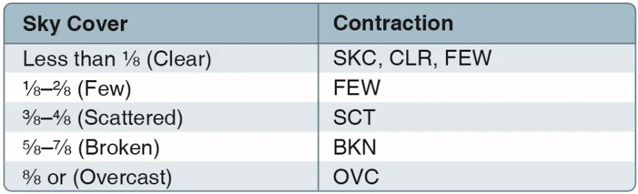
Cloud Coverage
| Abbreviation | Meaning | Coverage |
|---|---|---|
| SKC or CLR | Clear | 0/8 |
| FEW | Few | 1/8 to 2/8 |
| SCT | Scattered | 3/8 to 4/8 |
| BKN | Broken | 5/8 to 7/8 |
| OVC | Overcast | 8/8 (full coverage) |
The number after the coverage abbreviation is the cloud base height in hundreds of feet AGL:
FEW050= few clouds at 5,000 ft AGLBKN030= broken clouds at 3,000 ft AGLOVC010= overcast at 1,000 ft AGLVV004= vertical visibility 400 ft — an obscured sky (fog, heavy precip), not a cloud baseSCT050CB= scattered cumulonimbus at 5,000 ft — thunderstorm clouds, the only cloud type TAFs name
The ceiling is the lowest BKN or OVC layer. FEW and SCT never count.
Cloud heights in METARs are AGL, not MSL. Sectional charts use MSL. The exam will try to trip you up on this distinction — and “what’s the ceiling?” always means the lowest BKN/OVC, never the highest layer.
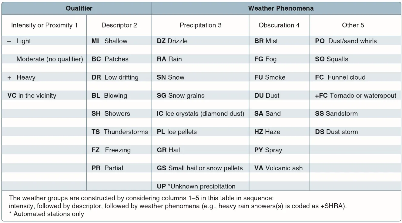
Weather Phenomena
| Code | Meaning |
|---|---|
| BR | Mist (visibility 5/8 SM to 6 SM) |
| FG | Fog (visibility less than 5/8 SM) |
| HZ | Haze |
| RA | Rain |
| SHRA | Rain showers |
| TSRA | Thunderstorm with rain |
| SN | Snow |
| -RA | Light rain |
| +RA | Heavy rain |
The Remarks Section (RMK)
Everything after RMK is supplementary. Two earn memory space: AO2 (automated station with precipitation discriminator — the most common remark) and PK WND 32035/1855 (peak wind 35 knots from 320° at 18:55Z — proof of what the gusts actually did).
Zulu Time Drills
Every timestamp is UTC — Zulu — on a 24-hour clock, prefixed by the day. Four drills:
- Format:
261755Z= day 26, 17:55 UTC. - Offset: Eastern Daylight = Z − 4; Pacific Standard = Z − 8; Arizona = Z − 7 year-round (the FAA’s example airports live in Phoenix — know this one).
- Date flip: 0000Z is midnight UTC — 5 PM Eastern the previous day. TIMELINE questions straddling 0000Z are the classic trap.
- TAF validity:
2618/2718runs from 1800Z on the 26th to 1800Z on the 27th — a 24-hour window that crosses a date boundary. Read both ends before answering “what’s forecast at 0900Z on the 27th?”
TAF — Terminal Aerodrome Forecast
TAF stands for Terminal Aerodrome Forecast. It covers the air within 5 SM of the center of the airport’s runway complex, valid 24 hours at most airports (30 at the majors). Same element grammar as a METAR, plus change groups.
Full Worked Decode
TAF KPHX 261700Z 2618/2718 27010KT P6SM SCT100
     TEMPO 2618/2622 27015G25KT 5SM TSRA BKN030CB
FM270000 24008KT P6SM SKCKPHX— Phoenix261700Z— issued 17:00Z on the 26th2618/2718— valid from 18:00Z on the 26th through 18:00Z on the 27th- Base line — wind 270 at 10, visibility above 6 SM, scattered at 10,000
TEMPO 2618/2622— through 22:00Z on the 26th, temporary fluctuations below that base: gusts to 25, 5 SM in thunderstorms, broken cumulonimbus at 3,000FM270000— a hard change at 00:00Z on the 27th: wind 240 at 8, above 6 SM, clear

The Change Groups
| Group | Meaning | Timing rule |
|---|---|---|
FM | From — rapid, lasting change | Everything changes at that instant |
BECMG | Becoming — gradual, permanent transition | New conditions rule at the end of the window |
TEMPO | Temporary fluctuations | Under an hour at a time, part of the period only |
PROB30/PROB40 | Probability 30% / 40% | Followed by time range + conditions |
The FAA tests the edges: when does a TEMPO stop applying (end of its window), when does a BECMG take effect (end of its window — the opposite of what most people guess), and what’s forecast at a specific time (match the time to the active group, chronologically). “When is thunderstorm activity expected?” = find the group containing TSRA, read its window.
Key Facts to Walk In With
ACS Area III references: III.A.K2, III.A.K3
- METAR grammar: station → Zulu time → wind → visibility → weather → sky → temp/dew → altimeter
- Wind: true north, from-direction, G = gusts, VRB, 180V260 variability
- Visibility: statute miles; P6SM; 3 SM = the Part 107 minimum from the control station
- RVR
R28L/2600FT: instrument-measured runway visibility in feet - CAVOK: vis ≥ 10 km, no clouds below 5,000 ft/MSA, no CB, no significant weather
- Ceiling = lowest BKN or OVC; cloud heights AGL; VV = obscured sky
- TAF change groups: FM (instant), BECMG (end of window), TEMPO (under an hour at a time), PROB30/40
- Zulu: 24-hour UTC; date flips at 0000Z; Arizona = Z − 7
Quick Check
Q: In a METAR, what does BKN030 mean?
A: Broken clouds (5/8 to 7/8 coverage) at 3,000 ft AGL.
Q: Wind is reported as 27010G20KT. What does this mean? A: Wind from 270 degrees at 10 knots, gusting to 20 knots.
Q: What does TEMPO mean in a TAF? A: Temporary — fluctuations lasting less than an hour at a time, during part of the period only.
Q: Decode R06L/2400FT.
A: Runway visual range of 2,400 feet on runway 6 Left — instrument-measured visibility far below drone minimums.
Q: When do a BECMG group’s new conditions take effect? A: At the end of its transition window — the common wrong answer is the start.
Q: 2618/2718 on a TAF — what does it cover?
A: 1800Z on the 26th through 1800Z on the 27th, a 24-hour validity window that crosses a date boundary.
What’s Next?
Now let’s learn where to get weather briefings and how to interpret the bigger picture: SIGMETs, AIRMETs, and official weather sources.
This free course covers the essential knowledge, but if you want video walkthroughs, practice exams, and instructor support, Pilot Institute’s Part 107 course is the most comprehensive option available.