METAR Decoded: A Drone Pilot's Guide to Aviation Weather Reports
Weather kills drone flights. Learn to read METARs and TAFs in under 30 seconds — the same format the FAA uses on the Part 107 exam.
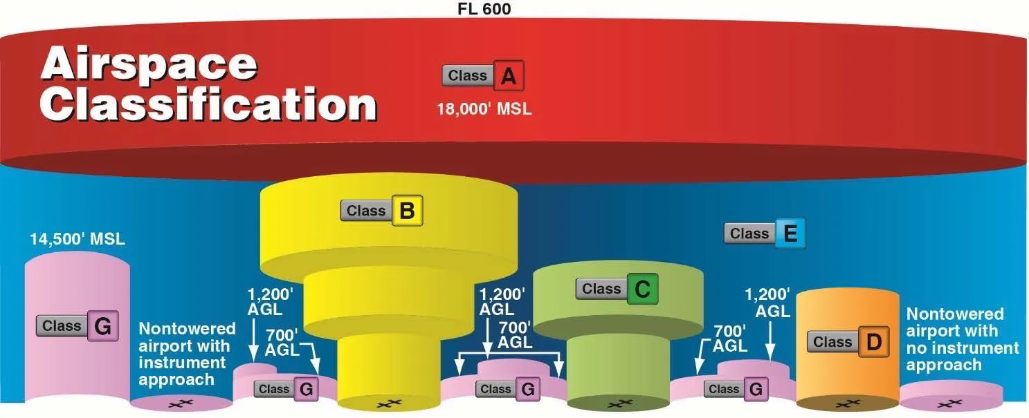
A METAR is a standardized aviation weather report displaying current conditions at an airport: wind direction and speed in knots, visibility in statute miles, cloud layers with altitude in hundreds of feet AGL, temperature/dew point in Celsius, and altimeter setting in inches of mercury. Part 107 pilots need minimum 3 statute miles visibility in Class B, C, D, and E surface airspace.
Weather kills drone flights. Not wind alone, not rain alone, but the combination of conditions you didn’t check before launching. The FAA knows this, which is why the Part 107 exam hammers you with METAR questions that catch unprepared pilots off guard.
You’ll see METARs on the test. You’ll see them in real life if you fly near airports. And if you can’t read one in under 30 seconds, you’re gambling with both your exam score and your aircraft.
What is a METAR?
METAR stands for Aviation Routine Weather Report. It’s a standardized format that reports current weather conditions at a specific airport or weather station.
These reports update every hour at most stations. Some high-traffic airports update more frequently. A METAR tells you exactly what’s happening right now — not what might happen in three hours.
Where do you find them? Aviation Weather Center (weather.gov) is the free government source. Apps like ForeFlight, AeroWeather, and UAV Forecast pull from the same data. For Part 107 studying, stick to the raw text format. The exam gives you the ugly string of letters and numbers, not a pretty decoded version.
Breaking Down a METAR
Here’s a real METAR from Phoenix Sky Harbor:
KPHX 151151Z 33012KT 10SM FEW050 SCT100 BKN250 25/15 A3012
Looks like a cat walked across a keyboard. But every character means something specific. Let’s crack it open.
KPHX — Station identifier. Every airport has a four-letter ICAO code. In the US, these start with “K.” KPHX is Phoenix. KLAX is Los Angeles. KJFK is New York Kennedy. If you see a METAR on the exam, the first thing to confirm is which airport it’s reporting from.
151151Z — Date and time in Zulu (UTC). The first two digits are the day of the month (15th). The next four are the time (11:51). The “Z” confirms Zulu time. No conversion required for most Part 107 questions — they usually just want you to know it’s current.
33012KT — Wind from 330 degrees at 12 knots. We’ll break this down more in the next section.
10SM — Visibility of 10 statute miles. Clear day.
FEW050 SCT100 BKN250 — Cloud layers at different altitudes. We’ll cover this too.
25/15 — Temperature 25°C, dew point 15°C. Fog prediction lives here.
A3012 — Altimeter setting 30.12 inches of mercury. The “A” stands for altimeter, and you drop the decimal point from 30.12.
That’s it. One line, complete weather picture.
Wind: Direction, Speed, and Gusts
Wind format in a METAR: DDDSSKT or DDDSSGSSKT
DDD = direction in degrees (true north, not magnetic) SS = speed in knots G = gusts (if present) KT = knots
33012KT means wind blowing FROM 330 degrees at 12 knots.
Important distinction: wind direction tells you where it’s coming from, not where it’s going. 330 degrees is coming from the northwest. If you’re facing north, 330-degree wind hits your left cheek and passes behind you to the right.
Gusts appear when wind speed varies significantly: 33012G25KT means steady 12 knots with gusts up to 25 knots.
Variable wind gets reported as VRB instead of a direction: VRB05KT means wind shifting directions at 5 knots. You’ll see this at airports surrounded by terrain or during calm conditions.
For drone pilots, gusts matter more than steady wind. Your aircraft might handle 12 knots fine but get knocked around by a 25-knot gust. When you see that “G” on the exam, flag it as a potential fly/no-fly factor.
Visibility and Flight Categories
Visibility in a METAR is always in statute miles, followed by “SM.”
10SM = 10 statute miles. Excellent visibility. 3SM = 3 statute miles. Minimum legal visibility for Part 107 in controlled airspace. 1/2SM = half a statute mile. Terrible.
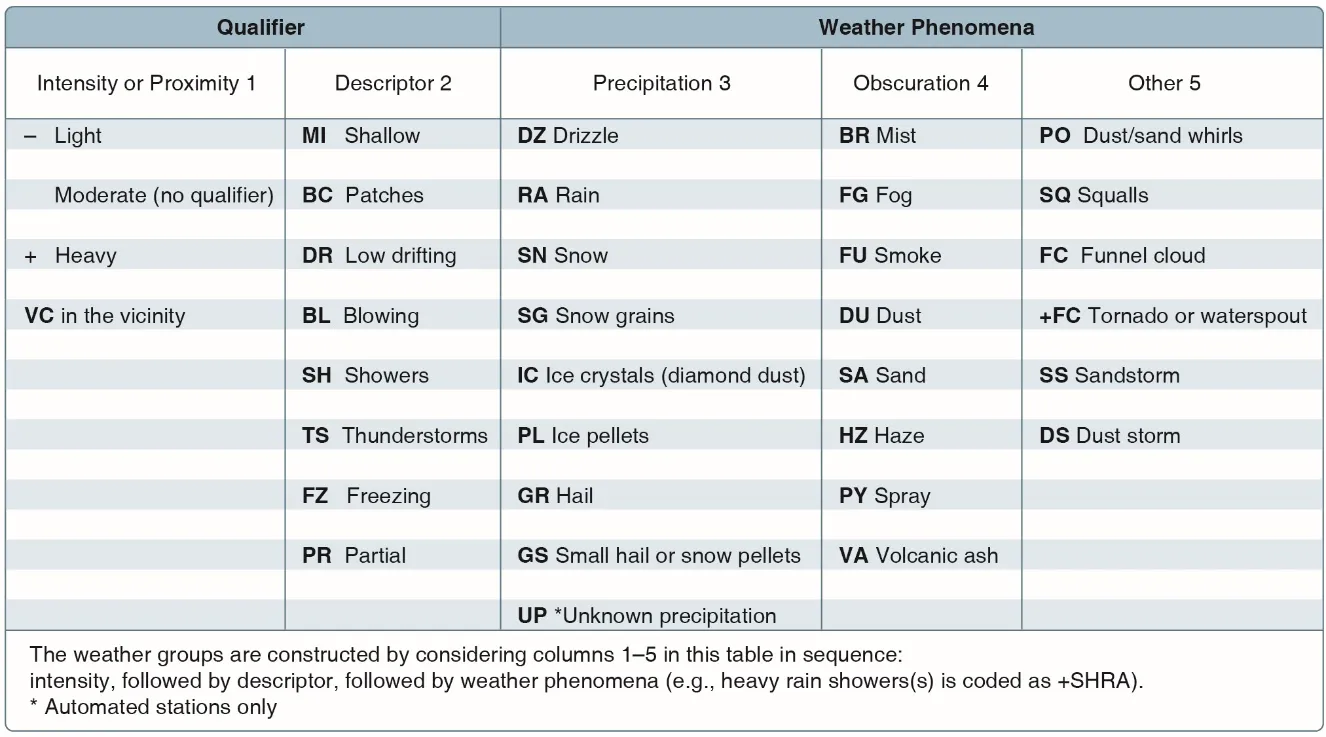
When visibility drops below 7 statute miles, METARs include the cause: 3SM BR means 3 miles visibility due to mist. 1/2SM FG means half mile visibility due to fog.
Flight Categories
The FAA classifies conditions into four categories:
VFR (Visual Flight Rules) — Ceiling above 3,000 feet AGL, visibility greater than 5 SM. Green on weather maps. Good flying.
MVFR (Marginal VFR) — Ceiling 1,000-3,000 feet AGL, visibility 3-5 SM. Blue on weather maps. Flyable but stay alert.
IFR (Instrument Flight Rules) — Ceiling 500-1,000 feet AGL, visibility 1-3 SM. Magenta on weather maps. Manned aircraft need instruments. Drones? Visibility under 3 SM means illegal in controlled airspace.
LIFR (Low IFR) — Ceiling below 500 feet AGL, visibility under 1 SM. Red on weather maps. Bad news for everyone.
For Part 107, memorize this: you need 3 SM visibility minimum in Class B, C, D, and E surface areas. If the METAR shows 2SM, you’re not flying there legally.
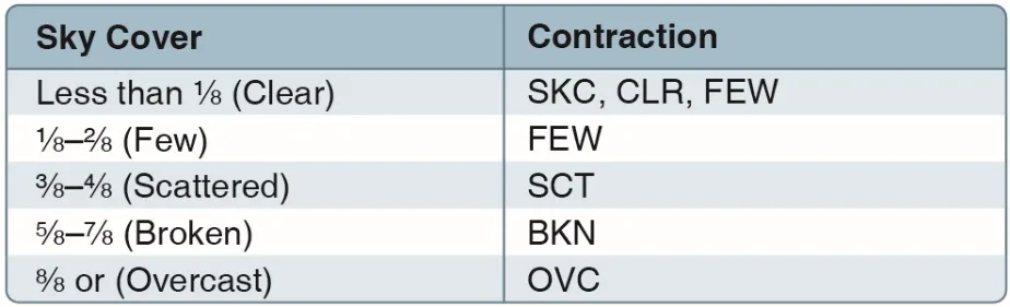
Cloud Layers: FEW, SCT, BKN, OVC
Clouds get reported in three-letter codes followed by altitude. The altitude is in hundreds of feet AGL (above ground level).
FEW050 = Few clouds at 5,000 feet AGL SCT100 = Scattered clouds at 10,000 feet AGL BKN250 = Broken clouds at 25,000 feet AGL OVC050 = Overcast at 5,000 feet AGL
The codes represent sky coverage in eighths:
- FEW = 1-2/8 of sky covered
- SCT = 3-4/8 of sky covered
- BKN = 5-7/8 of sky covered
- OVC = 8/8 of sky covered
What’s the Ceiling?
The ceiling is the lowest layer that’s BKN or OVC. In our example METAR (FEW050 SCT100 BKN250), the ceiling is 25,000 feet. Neither FEW nor SCT count as a ceiling because they don’t block enough sky.
If the METAR read BKN050 SCT100 OVC250, the ceiling would be 5,000 feet. That’s the lowest broken or overcast layer.
Why does ceiling matter for drones? Part 107 says you must fly below 400 feet AGL. But if the ceiling drops to 400 feet, you’ve got zero legal flying room. If ceiling is 300 feet and you’re in controlled airspace needing 3 SM visibility, you might be technically legal on visibility but practically foolish.
One Cloud Type to Fear: CB
CB means cumulonimbus. Thunderstorm clouds. The only cloud type specifically forecast in TAFs because of the danger.
If you see CB attached to any cloud layer, that’s a thunderstorm. SCT050CB means scattered thunderstorm clouds at 5,000 feet. Stay on the ground. Your drone isn’t winning that fight.
Temperature, Dew Point, and Fog Prediction
25/15 in a METAR means 25°C temperature, 15°C dew point.
The temperature-dew point spread tells you how close the air is to saturation. Closer spread = higher humidity = fog potential.
- Spread of 0-2°C: Fog likely
- Spread of 3-5°C: Mist possible
- Spread above 10°C: Dry, clear conditions
If you see a METAR with 15/14 and visibility dropping, fog is forming or about to form. The air is nearly saturated.
The dew point can never exceed the temperature. If they’re equal, you’re at 100% relative humidity. Water is condensing. That’s fog, mist, or clouds.
TAF vs METAR: Current vs Forecast
METAR = What’s happening right now. TAF = What’s expected to happen.
TAF stands for Terminal Aerodrome Forecast. It covers 24-30 hours into the future for a specific airport.
TAFs use the same format as METARs for weather elements but add change groups that tell you when conditions will shift. A TAF might start clear and forecast thunderstorms at 3 PM, then clearing by 6 PM.
Here’s a TAF snippet:
KPHX 151100Z 1512/1612 33012KT P6SM FEW050 SCT100
Breaking it down:
- KPHX — Phoenix
- 151100Z — Issued at 11:00 Zulu on the 15th
- 1512/1612 — Valid from 12:00 Zulu on the 15th through 12:00 Zulu on the 16th
- 33012KT P6SM FEW050 SCT100 — Initial forecast conditions (same format as METAR, but P6SM means “greater than 6 statute miles”)
TAF Change Groups: FM, TEMPO, PROB
TAFs predict weather changes using three main codes.
FM (From)
FM152000 means starting at 20:00 Zulu on the 15th, conditions change to whatever follows. FM groups are hard changes — the weather shifts abruptly at that time.
FM152000 18015G25KT 5SM -RA BKN030
Translation: At 20:00 Zulu, wind becomes 180 degrees at 15 gusting 25 knots, visibility drops to 5 miles with light rain, broken clouds at 3,000 feet.
TEMPO (Temporary)
TEMPO 1520/1522 means temporary conditions expected between 20:00 and 22:00 Zulu. TEMPO fluctuations last less than an hour at a time, and conditions only occur part of the period.
TEMPO 1520/1522 3SM TSRA
Translation: Between 20:00 and 22:00, temporarily expect visibility down to 3 miles with thunderstorms and rain. It won’t last the whole two hours, but it could happen at any point during that window.
PROB (Probability)
PROB30 means 30% chance of the following conditions occurring.
PROB30 1522/1524 1SM FG
Translation: 30% chance that between 22:00 and 24:00 Zulu, visibility drops to 1 mile due to fog.
You might also see PROB40 (40% chance). PROB is always followed by a time range and the expected conditions if that probability hits.
Reading TAFs on the Exam
The test often gives you a TAF and asks “When is thunderstorm activity expected?” or “What are the forecast conditions at 1800Z?”
For time-based questions, work through the TAF chronologically. Find the FM or TEMPO group that covers the target time. That’s your answer.
Common Exam Questions
Question 1
METAR: KORD 151200Z 18015G25KT 2SM BR OVC008 18/17 A2992
Based on this METAR, what is the ceiling at KORD?
A) 800 feet B) There is no ceiling C) 2 statute miles D) 800 meters
Answer: A) 800 feet
The ceiling is the lowest BKN or OVC layer. OVC008 means overcast at 800 feet AGL (008 x 100 = 800). Choice C is visibility, not ceiling. Choice D uses meters — aviation always uses feet. There is a ceiling, so B is wrong.
Question 2
METAR: KJFK 151500Z 21008KT 1/2SM FG A3010
A remote pilot wants to fly in Class D airspace near KJFK. Can they legally fly under Part 107?
A) Yes, visibility is adequate B) No, visibility is below minimums C) Yes, but only if they have a waiver D) No, wind is too strong
Answer: B) No, visibility is below minimums
The METAR shows 1/2SM visibility due to fog (FG). Part 107 requires minimum 3 statute miles visibility in Class D airspace. The wind at 8 knots is not a regulatory limitation. No waiver exists for visibility minimums.
Question 3
TAF: KLAS 151100Z 1512/1612 25010KT P6SM SCT050 FM152000 18015G25KT 4SM -SHRA BKN030 TEMPO 1522/1600 2SM TSRA CB
At 2100Z on the 15th, what are the forecast conditions?
A) VFR with scattered clouds B) 4 statute miles visibility with rain showers and broken clouds C) 2 statute miles with thunderstorms D) Overcast skies with light rain
Answer: B) 4 statute miles visibility with rain showers and broken clouds
At 2100Z, the FM152000 group is active. It forecasts 4SM visibility, light rain showers (-SHRA), broken clouds at 3,000 feet. The TEMPO group runs 2200-0000Z, so at 2100Z the thunderstorm conditions haven’t started yet. Always match your target time to the correct change group.
METAR Quick Reference
| Code | Meaning |
|---|---|
| Station | 4-letter ICAO code (K + 3 letters in US) |
| Time | DDHHMMZ (day, hour, minute, Zulu) |
| Wind | DDDSSKT (direction/speed/knots) |
| G | Gusts (e.g., 12G25KT) |
| VRB | Variable wind direction |
| SM | Statute miles (visibility) |
| P6SM | Greater than 6 statute miles |
| FEW | Few clouds (1-2/8 sky cover) |
| SCT | Scattered clouds (3-4/8) |
| BKN | Broken clouds (5-7/8) — counts as ceiling |
| OVC | Overcast (8/8) — counts as ceiling |
| CB | Cumulonimbus (thunderstorm) |
| Temp/Dew | TT/DD in Celsius |
| A#### | Altimeter in inches Hg (A3012 = 30.12) |
| BR | Mist |
| FG | Fog |
| HZ | Haze |
| RA | Rain |
| TSRA | Thunderstorm with rain |
| SHRA | Rain showers |
| FM | From (hard change in TAF) |
| TEMPO | Temporary fluctuations (TAF) |
| PROB | Probability of occurrence (TAF) |
Ceiling = Lowest BKN or OVC layer altitude Part 107 minimum visibility = 3 SM in Class B/C/D/E surface airspace Fog likely when = Temperature-dew point spread is 0-2°C
Practice Tips
Reading METARs is a skill built through repetition, not reading about it. Open aviationweather.gov right now and pull up a METAR for your closest airport. Decode it before scrolling down to the “translated” version.
For structured practice, the ASA Remote Pilot Test Prep includes hundreds of weather questions formatted exactly like the real exam. Work through every weather section twice.
The FAA Remote Pilot Study Guide is the official source material the test writers use. It’s dry, but it’s the truth. If you see a weather abbreviation in the study guide, memorize it — it’s fair game for the exam.
When you hit a METAR question on practice tests, don’t just pick an answer. Write out the full decode on scratch paper. Build the muscle memory of scanning left to right: station, time, wind, visibility, clouds, temp/dew, altimeter. On test day, that pattern keeps you from panicking when you see a long string of codes.
Pay special attention to questions with TAFs that span multiple change groups. The FAA loves testing whether you can identify which conditions apply at a specific time. Draw a timeline if you need to.
Weather is where pilots lose points they shouldn’t lose. It’s not that the concepts are hard — it’s that unprepared pilots see METAR code and freeze. Don’t be that pilot.
Frequently Asked Questions
What does the “G” mean in a METAR wind reading? The “G” indicates gusts. “33012G25KT” means steady winds from 330 degrees at 12 knots with gusts up to 25 knots. Gusts matter more than steady wind for drones because sudden bursts can knock your aircraft around even when average wind seems manageable.
How do you predict fog from a METAR? Check the temperature-dew point spread. A spread of 0-2\u00b0C means fog is likely, 3-5\u00b0C indicates mist is possible, and above 10\u00b0C means dry conditions. A reading like “15/14” with dropping visibility means fog is forming.
What does CB mean in a METAR cloud layer? CB stands for cumulonimbus (thunderstorm clouds). It’s the only cloud type specifically called out in TAFs because of the extreme danger. “SCT050CB” means scattered thunderstorm clouds at 5,000 feet AGL. Stay on the ground.
How often are METARs updated? Most stations update every hour. High-traffic airports may update more frequently. METARs report current conditions only. For forecasts covering 24-30 hours ahead, you need a TAF (Terminal Aerodrome Forecast).
What does P6SM mean in a weather report? Visibility greater than 6 statute miles. This notation appears primarily in TAFs. In METARs, you’ll see a specific number like “10SM” rather than the “P” prefix.
What does VRB indicate in wind data? Variable wind direction. “VRB05KT” means wind shifting directions at 5 knots. This occurs at airports surrounded by terrain or during calm conditions when no consistent direction exists.
Ready to master weather and every other Part 107 topic? Check out the free Part 107 Complete Course for video lessons, practice exams, and the confidence to pass on your first attempt.