Clouds, Fronts & Atmospheric Stability
Clouds form when rising air cools to its dewpoint, fronts are the boundaries where air masses fight, and stability decides whether the day is smooth haze or bumpy towers of cumulus. For a drone pilot the theory compresses to two habits: compute the cloud base from the temperature-dewpoint spread before you launch, and read the front’s type to know whether weather is hours away or minutes. Cumulonimbus ends every discussion — you land.
The Hydrologic Cycle
All weather starts with water cycling between the earth and atmosphere:

- Evaporation: water turns to vapor (requires heat)
- Condensation: vapor turns to droplets (forms clouds)
- Precipitation: water falls back to earth (rain, snow, hail)
- The cycle is driven by solar energy
Cloud Types
Knowing basic cloud types helps you assess conditions at a glance:
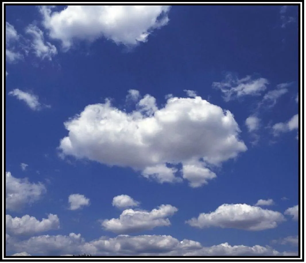
Low Clouds (below 6,500 ft AGL)
- Stratus (ST): flat, featureless, gray layers. Steady, light rain.
- Stratocumulus (SC): low, lumpy clouds with gaps. Usually no precipitation.
- Nimbostratus (NS): dark gray, thick layers. Steady moderate to heavy rain.
Middle Clouds (6,500–20,000 ft)
- Altocumulus (AC): patchy, rolling clouds. May signal approaching storms.
- Altostratus (AS): grayish veil. Rain possible.
High Clouds (above 20,000 ft)
- Cirrus (CI): wispy feathers. Usually fair weather, but can herald an approaching front.
- Cirrocumulus (CC): small white patches (“mackerel sky”). Fair weather.
- Cirrostratus (CS): thin milky veil. Halo around the sun or moon.
Clouds with Vertical Development
- Cumulus (CU): puffy cotton. Fair weather when isolated.
- Cumulonimbus (CB): thunderstorm clouds. EXTREMELY hazardous. Avoid at all costs.
Cumulonimbus (CB) = thunderstorm = do not fly. The FAA always tests this. If you see CB developing, land immediately.

How Clouds Form: The Lapse Rate Engine
Cloud formation is arithmetic, and the numbers are worth memorizing (FAA-H-8083-28, ch. 12):
- A rising unsaturated parcel cools at the dry adiabatic lapse rate: about 3 °C per 1,000 ft
- Its dewpoint drops only 0.5 °C per 1,000 ft
- The temperature-dewpoint spread therefore closes at 2.5 °C per 1,000 ft — when it reaches zero, the parcel saturates and cloud forms at that altitude, the Lifted Condensation Level (LCL)
That gives you the cloud-base estimate every pilot uses:
Cloud base (ft AGL) ≈ (Temperature − Dewpoint in °C) ÷ 2.5 × 1,000
The handbook’s own example: surface air at 18 °C with a 13 °C dewpoint. Spread = 5 °C → 5 ÷ 2.5 = 2 → cloud base ≈ 2,000 ft AGL. If your METAR reads 30/29, the spread is 1 °C and the base is a low stratus deck around 400 ft — that’s your entire legal flight envelope fogging in.
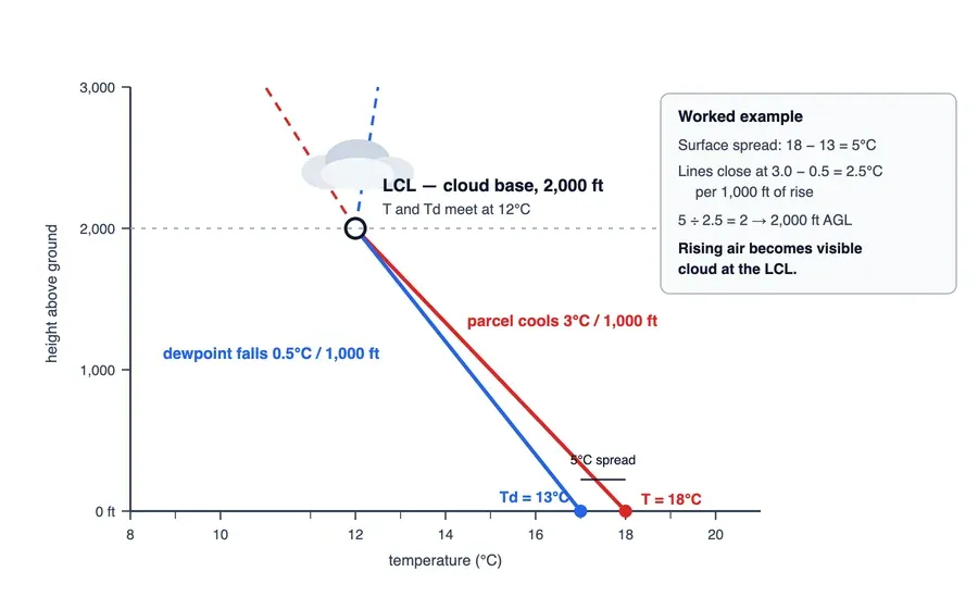 Two lines converging at 2,000 ft: air cooling at 3 degrees per thousand, dewpoint sliding at half a degree. Where they meet, cloud.
Once the parcel saturates, it cools more slowly at the moist adiabatic rate — 1.2 to 3 °C per 1,000 ft (the handbook simplifies to 2 °C), because condensation releases latent heat. That released heat is the engine of continued rise: it’s why unstable, saturated air builds cumulus into cumulonimbus instead of settling.
The spread is a countdown. A 2 °C spread means cloud (or fog) roughly 800 ft up — and closing, if the air keeps rising or the evening keeps cooling. The full worked treatment lives in the cloud base formula guide on the blog.
Atmospheric Stability
Stability determines whether air wants to rise or stay put:
Stable Air
- Resists vertical movement
- Smooth air, stratiform clouds, steady precipitation, poor visibility
- Fog and low stratus common
- Absolute stability includes isothermal layers and inversions (temperature increasing with height)
Unstable Air
- Continues rising once started
- Turbulent air, cumulus clouds, showery precipitation, good visibility (except in the showers)
- Thunderstorms possible
The comparison that matters: if the surrounding air cools faster with altitude than a lifted parcel does, the parcel stays warmer than its environment and keeps rising — instability. If the environment cools more slowly (or warms), the parcel chills and sinks back — stability.
Unstable air means turbulence, which makes control and smooth footage harder. Stable air means smoother flights but potentially worse visibility. Pick your poison with the forecast.
Air Masses
An air mass is a large body of air with similar temperature and moisture throughout:

| Air Mass | Source Region | Characteristics |
|---|---|---|
| Continental Polar (cP) | Canada/Alaska | Cold, dry |
| Continental Tropical (cT) | Desert SW | Hot, dry |
| Maritime Polar (mP) | North Pacific/Atlantic | Cool, moist |
| Maritime Tropical (mT) | Gulf of Mexico/Atlantic | Warm, moist |
| Arctic (A) | Arctic region | Very cold, dry |
Fronts
A front is the boundary between two air masses. Read the type and you know the timeline.
Cold Front

- Cold air advances, wedges under the warm air
- Steep slope: rapid lifting, thunderstorms if the warm air is unstable
- Typically moves 25–30 mph (extreme cases to 60 mph) — faster than warm fronts
- Weather: cumulus/CB, heavy rain showers, lightning, hail; squall lines can form ahead of the front
- After passage: weather clears quickly, gusty westerly-to-northwesterly winds, cooler temps, rising pressure
Warm Front

- Warm air advances, rides up and over the colder, denser air
- Gentle slope: gradual lifting, widespread layered clouds
- Slower than a cold front
- Weather: cirrus → cirrostratus → altostratus → nimbostratus in sequence, steady rain, fog, poor visibility that can linger
- After passage: stratocumulus, improving-but-hazy visibility, southerly winds
Stationary Front

- Neither air mass advances; the boundary parks
- Weather can persist for days in the same area
- A mix of warm-front and cold-front conditions
Occluded Front

- A fast cold front catches the warm front ahead of it
- The most complex weather: warm-front conditions arrive first, cold-front weather immediately behind
- Two flavors — cold occlusion (advancing air colder) and warm occlusion (air ahead colder) — the warm occlusion can be the nastier one, with embedded thunderstorms, rain, and fog
Passage Signatures at a Glance
| Signal | Cold front | Warm front |
|---|---|---|
| Wind before | S-SW, gusty | S-SE, steady |
| Pressure before | falling fast | falling steadily |
| During | gusty/variable, heavy showers | stratiform clouds, drizzle, poor vis |
| Wind after | W-NW | S-SW |
| Temp/dewpoint after | both drop | temp rises, dewpoint rises then levels |
| Sky after | clears rapidly | stratocumulus, hazy |
Reading Fronts on the Surface Map
On surface analyses and forecast maps, the fronts carry a color code: blue lines with triangles point in the direction a cold front is moving; red lines with semicircles mark a warm front; alternating triangles and semicircles on both sides mean the front is stationary; purple (both symbols together) marks an occlusion. Triangles and semicircles always point where the front is headed — a stationary front’s symbols face opposite ways because nothing’s going anywhere.
Key Facts to Walk In With
ACS Area III references: III.B.K1c–d
- Dry adiabatic lapse rate ≈ 3 °C/1,000 ft; dewpoint −0.5 °C/1,000 ft; moist rate 1.2–3 °C/1,000 ft
- Cloud base ≈ (T − Td) ÷ 2.5 × 1,000 ft AGL
- Stable: smooth, stratus, steady precip, poor vis; unstable: turbulent, cumulus, showers
- CB = never fly; cold front = fast, violent, then clear; warm front = slow, gray, lingering
- Cold occlusion vs warm occlusion; squall lines ahead of fast cold fronts
- Map: blue triangles (cold), red semicircles (warm), alternating (stationary), purple (occluded)
Quick Check
Q: Which cloud type indicates thunderstorms? A: Cumulonimbus (CB). Avoid all CB.
Q: What type of weather does a cold front typically bring? A: Thunderstorms, heavy showers, gusty winds — then rapid clearing behind the front.
Q: Stable air produces what type of clouds and precipitation? A: Stratiform clouds, steady precipitation, smooth air, poor visibility.
Q: METAR reads 24/18. Estimate the cloud base. A: Spread 6 °C → 6 ÷ 2.5 = 2.4 → roughly 2,400 ft AGL.
Q: A surface map shows a line with triangles on one side and semicircles on the other. What is it? A: A stationary front — each symbol faces the air mass it would push into, and neither is moving.
What’s Next?
Now that we understand weather theory, let’s look at specific hazards: thunderstorms, wind shear, fog, and icing, plus the minimum weather conditions for safe drone operations.
This free course covers the essential knowledge, but if you want video walkthroughs, practice exams, and instructor support, Pilot Institute’s Part 107 course is the most comprehensive option available.