Airspace Classification
The FAA sorts U.S. airspace into seven classes, A through G, and for a drone pilot they all reduce to one question: is the air you want to fly in controlled or uncontrolled? Classes B, C, D, and the surface areas of Class E require prior ATC authorization before a Part 107 flight (14 CFR §107.41). Class G does not. Learn where each class lives and the sectional chart makes your go/no-go call for you.
Why Airspace Matters for Drone Pilots
Airspace classification determines whether you can fly in a given area and whether you need authorization. This is the second most tested topic on the Part 107 exam (Airspace is 15–25% of the 60 questions, per the ACS Area II weighting). Every airspace question ties back to knowing which class you’re standing in.
The FAA divides airspace into two categories:
- Controlled airspace (Classes A, B, C, D, E) — IFR separation services are provided here, and drone operations generally need prior authorization
- Uncontrolled airspace (Class G) — no ATC authorization needed for Part 107 ops; you’re still bound by all the Part 107 operating rules
In controlled airspace, ATC separates aircraft flying under instrument flight rules. A drone flight under Part 107 is still see-and-avoid — nobody is watching you specifically. “Controlled” is about the IFR system, and for you it means one practical thing: authorization before you launch.
What Is Class A Airspace?
- Altitude: from 18,000 ft MSL up to and including FL600 (60,000 ft)
- IFR only — “Unless otherwise authorized, all persons must operate their aircraft under IFR” (AIM ¶3-2-2)
- Not charted as a distinct area — it’s simply everything above 18,000 ft MSL
- Not relevant for drone pilots: your ceiling under §107.51(b) is 400 ft AGL, so you will never legally operate in Class A
You’ll see exactly one Class A question on the exam, if any. Walk in knowing the two numbers — 18,000 MSL and FL600 — and move on.
What Is Class B Airspace?
- Around the busiest U.S. airports — JFK, LAX, ATL, about 37 of them nationwide
- Generally from the surface up to 10,000 ft MSL (AIM ¶3-2-3)
- Individually tailored, with multiple concentric layers — inner core to the surface, outer shelves with raised floors (some resemble upside-down wedding cakes)
- Drone operations require prior ATC authorization (14 CFR §107.41)
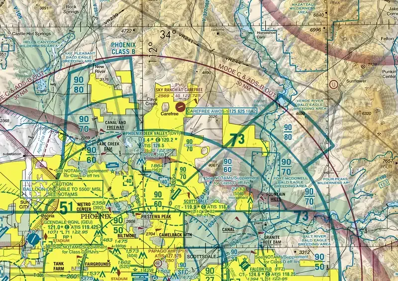 Class B from above: solid blue rings, each shelf labeled with its ceiling/floor in hundreds of feet MSL. Outer shelves ride above a raised Class G floor.
Class B is shown as solid blue circles on sectional charts. If you see solid blue, think “Big, Busy, Blue.” Major airports, strictest rules. The shelf floors are printed in MSL numbers inside each ring — the exam loves asking what the floor of an outer shelf is, not the ceiling.
What Is Class C Airspace?
- Around moderately busy airports with an operational control tower and a radar approach control
- Two concentric areas (AIM ¶3-2-4):
- Inner core: 5 NM radius, from the surface up to 4,000 ft above the airport elevation
- Outer shelf: 10 NM radius, from no lower than 1,200 ft up to 4,000 ft above the airport elevation
- Charted in MSL, so the shelf floor on the chart might read 1,600 or 2,100 depending on airport elevation
- Drone operations require prior ATC authorization
Class C is solid magenta circles on sectional charts. “C” for “City.” Medium cities with towered airports. Memorize the geometry: 5 NM core, 10 NM shelf, top at 4,000 ft above airport elevation — not 4,000 ft MSL.
What Is Class D Airspace?
- Around airports with an operational control tower (no radar approach requirement)
- Single area: from the surface up to 2,500 ft above the airport elevation (AIM ¶3-2-5), shown as a bracketed number like
[29]meaning 2,900 ft MSL - Drone operations require prior ATC authorization
- When the tower closes part-time, the airspace typically reverts to Class E or G — the Chart Supplement tells you which

Class D is a dashed blue circle on sectional charts. “D” for “Dashed.” The number in brackets is the ceiling in MSL — the exam tests whether you can convert it: bracket [29] minus airport elevation 400 ft = 2,500 ft above the airport.
What Is Class E Airspace?
Class E is the catch-all for controlled airspace that isn’t A, B, C, or D. If airspace is controlled but doesn’t fit the airport-shaped classes, it’s E — and it comes in more forms than the rest combined. Know all of them:
Class E Surface Area
- Dashed magenta line around an airport
- Extends from the surface up to the overlying controlled airspace
- Authorization required — this is the one Class E form §107.41 names explicitly: “within the lateral boundaries of the surface area of Class E airspace designated for an airport”
Class E Extensions
- Dashed magenta lines extending out from Class B/C/D surface areas along instrument approach corridors
- Treated like the surface area they serve for authorization purposes
Class E Starting at 700 ft AGL
- Soft magenta gradient (feathered vignette) on sectional charts
- Below 700 ft AGL = Class G (no authorization needed)
- Above 700 ft = Class E (authorization required)
- Marks airports with approved instrument procedures; common across the eastern U.S.
Class E Starting at 1,200 ft AGL
- Soft blue gradient on sectional charts — or no marking at all in remote areas
- Below 1,200 ft AGL = Class G
- Above 1,200 ft = Class E
- The default over most of the western U.S.
Federal Airways: Class E in the Sky
Victor airways — the routes manned IFR traffic flies between VOR stations — are themselves Class E airspace. Unless otherwise charted, they run from 1,200 ft AGL up to (but not including) 18,000 ft MSL, and they’re 8 NM wide: 4 NM each side of the centerline (AIM ¶3-2-6, ¶5-3-5). For a 400-ft drone flight this rarely binds, but it explains why controlled airspace can appear over otherwise empty terrain: you’re under an airway. Low-altitude RNAV routes (T-routes) and the old colored NDB airways (green, red, amber, blue) carry the same Class E classification.
If you’re flying at 400 ft AGL and you see soft magenta shading, you’re in Class G — the controlled floor starts at 700 ft. Same with soft blue: Class E doesn’t start until 1,200 ft. But dashed magenta means Class E to the ground: authorization required at any altitude.
What Is Class G Airspace?
- Uncontrolled — “that portion of airspace that has not been designated as Class A, Class B, Class C, Class D, or Class E” (AIM ¶3-3-1)
- Not depicted on sectional charts — it’s the absence of any other marking
- Where most Part 107 operations happen
- No ATC authorization needed, but every Part 107 rule still applies: 400 ft ceiling, visual line of sight, daylight/VLOS weather minimums, and the rest
Class G is where you can fly on your own authority. Every other class — including each form of Class E that starts at the surface — requires some form of authorization first.
When Does a Drone Pilot Need ATC Authorization?
The controlling rule is 14 CFR §107.41, verbatim:
No person may operate a small unmanned aircraft in Class B, Class C, or Class D airspace or within the lateral boundaries of the surface area of Class E airspace designated for an airport unless that person has prior authorization from Air Traffic Control (ATC).
Three practical takeaways:
- The trigger is B, C, D, or Class E-to-the-surface. Class E that starts at 700 or 1,200 ft AGL is not named by §107.41 — it’s not an authorization airspace, whether you fly below its floor in Class G or above it.
- Authorization comes before the flight, not after launch. The two standard routes are LAANC (near-real-time approval for low-altitude gridded areas around airports) and the FAA’s manual DroneZone application for everything LAANC can’t handle.
- Operating without it is a federal rule violation, not a courtesy slip — it’s treated the same as busting Class B in a manned aircraft.
The exam phrases this as “prior authorization from ATC.” If an answer choice says “notification” alone, or “permission from the airport manager,” it’s wrong. The word is authorization, and it comes from ATC.
How Do You Read the E-to-G Transition on a Sectional?
This is the single most drillable skill in the airspace area. Every sectional shows where Class E’s floor sits, and below that floor is Class G. Work it in three steps:
- Find the marking: dashed magenta (surface area), feathered magenta (700 ft floor), feathered blue (1,200 ft floor), or nothing at all (default 1,200 ft floor in the continental U.S.).
- State the floor: “Class E begins at 700 AGL here” or “Class E begins at the surface here.”
- Compare to your altitude: a 400-ft flight under a 700-ft or 1,200-ft floor is in Class G — no authorization. The same flight inside dashed magenta is inside Class E from the ground up — authorization required.
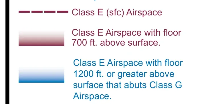 The two gradients, side by side: magenta feathering means Class E begins at 700 ft AGL; blue feathering means 1,200 ft. Below either floor is Class G.
Worked example: a magenta vignette surrounds a town with an instrument approach. The chart’s floor is 700 AGL. Your mission is a rooftop inspection at 300 ft AGL. Class E starts 400 ft above you — you’re in Class G, and §107.41 doesn’t apply. The same rooftop at face level into dashed magenta? Authorization first, every time.
Airspace Summary Table
| Class | Shape on Chart | Color | Floor | Auth Required? |
|---|---|---|---|---|
| A | Not charted | — | 18,000 ft MSL | IFR only (not for sUAS) |
| B | Solid concentric circles | Blue | Surface (shelved layers) | Yes |
| C | Solid concentric circles | Magenta | Surface (core); ≥1,200 ft (shelf) | Yes |
| D | Dashed circle | Blue | Surface | Yes |
| E (surface) | Dashed line | Magenta | Surface | Yes |
| E (700 ft) | Soft vignette | Magenta | 700 ft AGL | No — not a §107.41 airspace |
| E (1200 ft) | Soft vignette | Blue | 1,200 ft AGL | No — not a §107.41 airspace |
| Federal airway | Solid line w/ V-number | — | 1,200 ft AGL | No — not a §107.41 airspace |
| G | Not depicted | — | (default) | No |
Key Facts to Walk In With
ACS Area II references: II.A.K1a–e, II.A.K4
- Class A: 18,000 ft MSL to FL600, IFR only
- Class B: surface to 10,000 ft MSL, ~37 airports, solid blue
- Class C: 5 NM core + 10 NM shelf, top at 4,000 ft above airport elevation, solid magenta
- Class D: surface to 2,500 ft above airport elevation, dashed blue
- Class E floors: 700 ft (magenta vignette) / 1,200 ft (blue vignette); airways 1,200 ft AGL to below 18,000 ft MSL, 8 NM wide
- Class G: everything not A–E; no authorization
- §107.41: prior ATC authorization in B, C, D, and Class E surface areas
Quick Check
Q: What color are Class B airspace circles on a sectional chart? A: Solid blue.
Q: You see soft magenta shading on the chart. If you fly at 400 ft AGL, do you need authorization? A: No. Soft magenta means Class E starts at 700 ft AGL. Below that floor is Class G.
Q: Which airspace class covers most of the US near the surface? A: Class G. It’s everywhere that isn’t specifically designated as something else.
Q: What is the top of Class D airspace around an airport at 500 ft elevation? A: 3,000 ft MSL — 2,500 ft above the airport elevation, and Class D is charted in MSL.
Q: A Victor airway crosses your flight area. Do you need authorization to fly at 300 ft AGL beneath it? A: No. Federal airways are Class E starting at 1,200 ft AGL. Below the floor you’re in Class G.
What’s Next?
Now that you know the airspace classes, let’s look at special use airspace: restricted areas, prohibited areas, MOAs, and TFRs.
This free course covers the essential knowledge, but if you want video walkthroughs, practice exams, and instructor support, Pilot Institute’s Part 107 course is the most comprehensive option available.