Preflight Planning & Inspection
Before every flight, the remote PIC must assess the environment, brief the crew, verify the control links, confirm power, and check the aircraft’s condition — that’s §107.49’s list, and it’s the skeleton of every preflight question on the exam. Layered on it: airspace authorization (LAANC), NOTAMs and TFRs, weather, and — for night work — the items that only matter after dark. This lesson assembles the full sequence in the order you’ll actually run it.

Operations: The Biggest Exam Section
Operations accounts for 35–45% of the Part 107 exam — the single largest section, spanning preflight preparation through emergency procedures and decision-making. The regulations behind this lesson are short; the habit they build is the whole job.
The Regulatory Core: §107.49
The preflight rule, condensed (full text in Lesson 4):
- Assess the operating environment — weather, airspace and restrictions, people and property, ground hazards
- Brief all direct participants — conditions, emergency and contingency procedures, roles, hazards
- Verify control links
- Ensure sufficient power for the intended time
- Secure any carried objects
- Category compliance for over-people flights
Everything below is how you execute that list in the field.
Mission Planning
Define the operation before touching the aircraft:
- What: inspection, mapping, photography, delivery?
- Where: exact location, altitudes required, airspace above?
- When: time of day (daylight? civil twilight? night?), weather window?
Airspace and Authorization
- Sectional chart review: what class? What floors? Do you need §107.41 authorization?
- LAANC if you’re in controlled airspace
- NOTAMs for the flight area
- TFRs — the check that never gets skipped
LAANC in Depth
LAANC — Low Altitude Authorization and Notification Capability — is the near-real-time authorization system for drone flights in controlled airspace (Class B/C/D and Class E surface areas around airports). What it replaces: waiting days for manual DroneZone applications for ordinary low-altitude work.
How it actually works:
- The FAA publishes UAS Facility Maps that divide the controlled airspace around each airport into grid squares, each stamped with a maximum altitude (from 0 up to 400 ft)
- Within a grid’s published ceiling, participating LAANC apps (Aloft and others) get you automatic, near-instant authorization
- Need to fly above the grid value? That’s “further coordination” — submit at least 96 hours in advance through a LAANC app or DroneZone, and the FAA works it manually
- Authorization in hand, fly within its terms: the altitude, the area, the time window
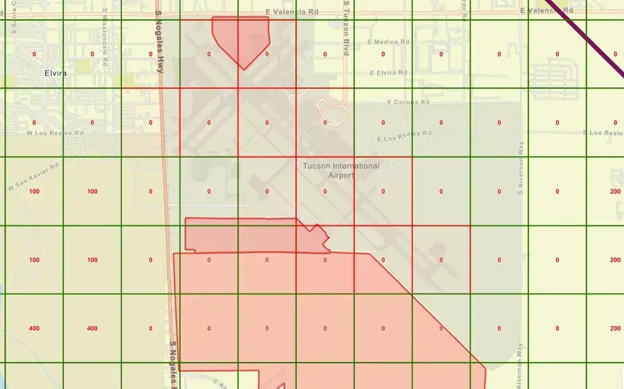 A UAS Facility Map: each square is its own LAANC ceiling. Inside the number, instant authorization; above it, further coordination 96 hours ahead.
LAANC questions on the exam cluster on the concept: near-real-time ATC authorization for low-altitude controlled-airspace operations, keyed to grid ceilings. It satisfies §107.41 — it doesn’t replace it.
Deciphering NOTAMs
A NOTAM (Notice to Air Missions) is time-critical information that isn’t yet — or won’t ever be — on the chart. The anatomy of a NOTAM reference:
!PHX 06/004 - PHX AIRSPACE UAS OPS WI AN AREA DEFINED AS 2NM RADIUS
OF LAT 33.435167 LONG -112.010833 SFC-400FT- The
!+ location opens a local/dispatch NOTAM; FDC NOTAMs (regulatory — TFRs live here), D (distant), and O (obstruction) prefixes mark other classes - DD/NNN is the date and serial
- The body abbreviates:
WI= within,R= radius,SFC-400FT= surface to 400 feet,UAS= unmanned aircraft operations,ABV= above,TFR= temporary flight restriction
For drone pilots, three NOTAM categories matter most:
- FDC TFR NOTAMs — the wildfire, VIP, and stadium restrictions that turn legal airspace illegal
- Airspace UAS NOTAMs — other drone operations’ reserved blocks (and the format you’ll see when your own ops get NOTAM’d)
- Obstruction NOTAMs — new towers and cranes not yet charted
Check them through 1800wxbrief.com, the FAA NOTAM site, or your flight app — every flight (§107.49(a)(2) makes it regulatory, not advisory).
The NOTAM check is required prior to every flight — not just flights near airports, not just controlled airspace. A TFR can exist over empty Class G farmland.
Weather Check
- Current METAR at the nearest airport — visibility, wind, clouds, spread
- TAF covering your operating window, including TEMPO groups
- AIRMETs / SIGMETs touching your region
- Your own eyes: does the sky match the report? (Visibility is judged from your control station — §107.51(c).)
Site Survey
On arrival, before the aircraft leaves the case:
- Obstacles: towers, wires, cranes, trees — charted and uncharted
- People and property: who’s here, where can they wander?
- Terrain: slopes, elevation changes, alternate landing sites
- Interference sources: power lines, radio towers, metal structures, 5 GHz congestion
- Launch/recovery area: flat, clear, and under your control
Night Preflight (V.F.K6)
Night adds a short list to the survey — miss one and the flight is either illegal or short:
- Anti-collision light: installed, powered, visible 3 SM, flash rate sufficient — the §107.29 requirement, verified by walking 50+ feet away before launch
- Position/orientation lighting so you can hold VLOS attitude awareness against a dark background
- Illuminated site survey: obstacles you saw at 3 PM vanish at 9 PM — walk the perimeter with a flashlight, and remember unlit wires don’t exist to your eye
- Depth-perception traps: city lights, water reflections, and featureless dark terrain all lie — plan wider margins from obstacles than you would by day
- Crew night briefing: lost-procedure, light-signal conventions, and who watches which sky sector
Preflight Inspection
Physically check the aircraft before every flight — this is §107.15’s “condition for safe operation” determination:
- Airframe: cracks, loose fasteners, damaged arms
- Propellers: chips, cracks, secure attachment — the cheapest part to replace and the most expensive to ignore
- Motors: spin freely, no grinding
- Battery: charged, no swelling, seated securely
- Camera/sensor: clean lens, secure mount
- GPS: adequate satellite lock before launch
- Control station: charged, bound, firmware current
- Remote ID: broadcasting before takeoff (standard-RID aircraft enforce this themselves — §89.310)
§107.15(a) makes the PIC’s preflight condition check the regulatory act: “Prior to each flight, the remote pilot in command must check the small unmanned aircraft system to determine whether it is in a condition for safe operation.” If someone else assembled the aircraft, the check — and the accountability — are still yours.
Contingency Planning
The preflight brief isn’t complete until the failure branches exist. Three questions, answered before launch:
- Where does the aircraft go if the link drops now? Walk the RTH path in your head at three points during the mission profile — climb-out, mid-mission, and return — and confirm each stays clear of people, obstacles, and the neighboring airport’s approach. Set the RTH altitude above the tallest obstacle on the path, not above the mission altitude.
- Where does it land if it can’t come home? Identify the contingency landing sites along the flight path — open ground, rooftops you have permission to damage, parking areas — and brief them, because the emergency that takes the link usually takes your deliberation time with it.
- Who does what when it goes wrong? If you have a VO: they call out traffic and clear bystanders; you fly. Solo: bystander management is the job you do while hand-flying the emergency. Decide, don’t improvise.
Documents to Have Available
- Remote Pilot Certificate and government ID (physically possessed — §107.7)
- Drone registration
- LAANC authorization (if applicable)
- Any waivers and their operating documents

Key Facts to Walk In With
ACS references: I.B.K20, II.B.K2, V.F.K2, V.F.K6
- §107.49 preflight list (environment, briefing, links, power, cargo, category)
- LAANC: near-real-time, grid ceilings via UAS Facility Maps, further coordination ≥96 hours out
- NOTAM anatomy:
!/FDC/D prefixes, WI, SFC-xxx, check every flight - §107.15 preflight condition check is the PIC’s personal duty
- Night additions: 3-SM anti-collision verification, walked site survey, wider obstacle margins
Quick Check
Q: What does LAANC provide? A: Near-real-time ATC authorization for low-altitude drone flights in controlled airspace, up to each grid’s UAS Facility Map ceiling.
Q: You need 300 ft in a grid capped at 100 ft. What’s the path? A: Further coordination — apply at least 96 hours ahead via LAANC/DroneZone for FAA manual review.
Q: Who is responsible for ensuring the drone is safe to fly? A: The remote PIC, by personal preflight check, every flight (§107.15).
Q: Decode “SFC-400FT” in a UAS NOTAM. A: The reserved airspace runs from the surface to 400 feet.
Q: What night item must you verify before launch that daylight flights never need? A: Anti-collision lighting visible for 3 statute miles with a sufficient flash rate (§107.29).
What’s Next?
Now let’s look at airport operations: runway markings, signage, traffic patterns, and how to operate safely near airports.
This free course covers the essential knowledge, but if you want video walkthroughs, practice exams, and instructor support, Pilot Institute’s Part 107 course is the most comprehensive option available.