The Atmosphere & Density Altitude
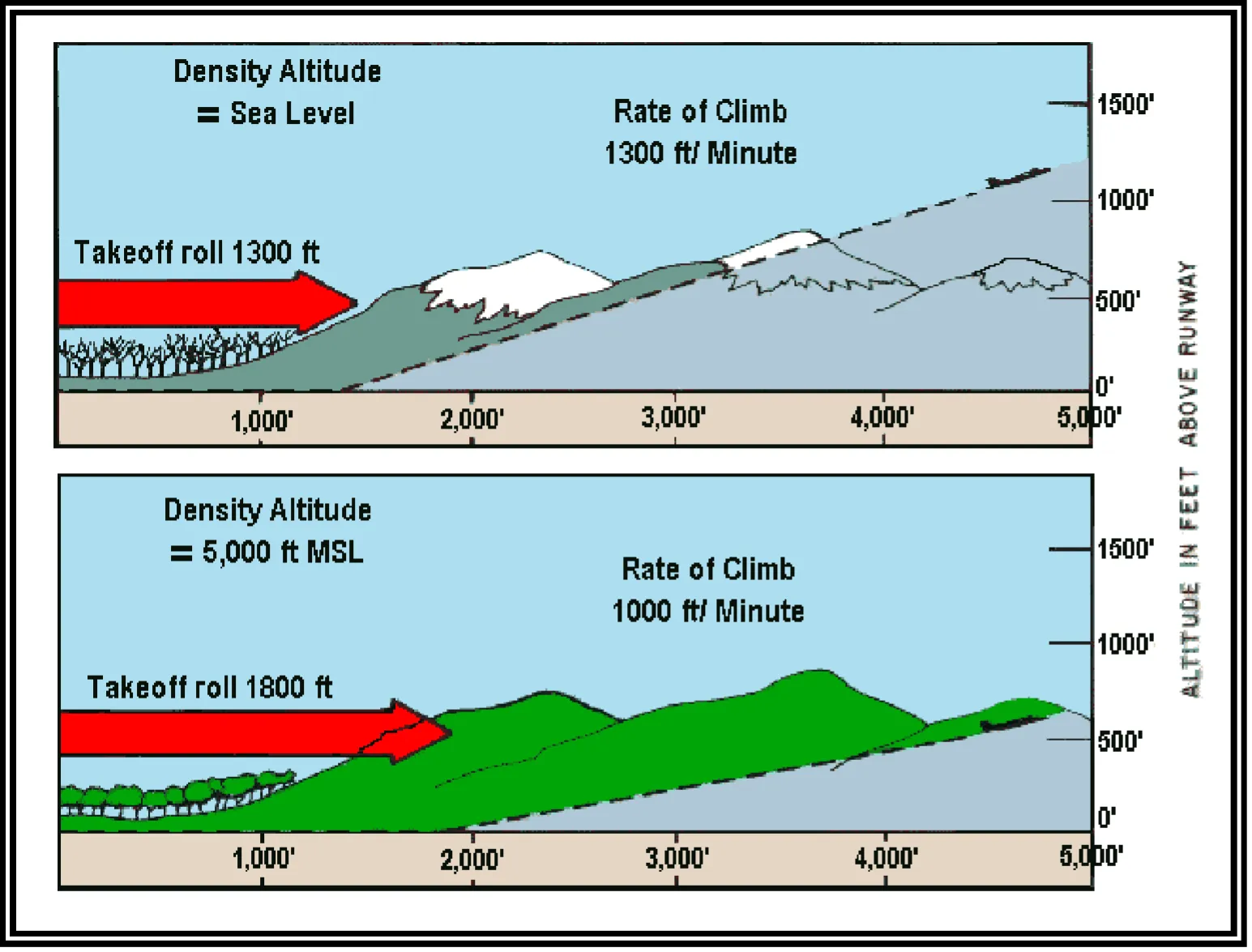
Density altitude is pressure altitude corrected for temperature — the altitude your aircraft feels like it’s at. On a 100 °F day at a 5,000-ft field, a drone performs as though flying several thousand feet higher than the map says: less lift from the props, less thrust per watt, shorter battery, slower climb. The three numbers to own are 15 °C, 29.92, and 2 °C per 1,000 ft — the standard atmosphere — because density altitude is measured as the deviation from them.
Why Weather Matters
Weather accounts for 11–16% of the Part 107 exam (ACS Area III), but it affects every flight you’ll ever make. Understanding the atmosphere isn’t academic: it determines whether your drone can safely fly, how long the battery lasts, and whether you’ll meet hazardous conditions.
Layers of the Atmosphere
The atmosphere has several layers, but drone pilots only need the lowest:
- Troposphere: ground level up to roughly 36,000 ft in the mid-latitudes (higher near the equator, lower at the poles; varies with season). This is where ALL weather happens. Temperature decreases with altitude at about 2 °C per 1,000 ft (roughly 3.5 °F).
- Tropopause: the boundary between troposphere and stratosphere. Weather stops here.
- Stratosphere: above the tropopause. Stable, no weather. Not relevant for drones.
ALL weather occurs in the troposphere, and the temperature drops about 2 °C (3.5 °F) per 1,000 ft of climb. It’s 20 °C cooler at 10,000 ft than at the valley floor — which is also why mountain flying couples terrain and temperature penalties in one flight.
Standard Atmosphere
The FAA defines a “standard day” as the baseline every altimeter and performance number references:
| Parameter | Standard value |
|---|---|
| Temperature at sea level | 15 °C (59 °F) |
| Pressure at sea level | 29.92 inHg (1013.2 hPa) |
| Temperature lapse rate | 2 °C per 1,000 ft |
| Pressure lapse rate | about 1 inHg per 1,000 ft |
When actual conditions differ from standard — which is nearly always — performance changes. Density altitude is how you measure the difference.
Atmospheric Pressure

Air has weight. Atmospheric pressure is the weight of the column of air above a given area.
- High pressure = descending air, generally clear weather
- Low pressure = rising air, generally cloudy or stormy weather
- Pressure decreases with altitude — less air remains above you
How Pressure Affects Drones
- Higher pressure = denser air = more lift for propellers = better performance
- Lower pressure = thinner air = less lift = reduced performance

Pressure Altitude: The First Step
Pressure altitude is “the altitude (above MSL) shown by the altimeter when set to 29.92” (FAA-H-8083-28, §8.4.1.4). It strips weather-driven pressure variations out of the picture so altitudes compare apples to apples.
Two ways to get it:
- The physical way: set a barometric altimeter to 29.92 and read it.
- The arithmetic way: take the field elevation, and adjust 1,000 ft for each 0.01 inHg the local altimeter setting differs from 29.92 — up if pressure is lower, down if higher. Altimeter 29.82 at a 2,000-ft field → pressure altitude ≈ 3,000 ft.
Density Altitude — The Performance Killer
Density altitude is “the pressure altitude corrected for temperature deviations from the standard atmosphere.” It’s the altitude the aircraft feels like it’s at.
- High density altitude = thin air = poor performance
- Low density altitude = dense air = good performance
Per the handbook, high density altitude degrades performance three ways at once:
- Less power — combustion has less air to work with
- Less thrust — less air mass for the propellers to push
- Less lift — the air exerts less force on the airfoils (your props are airfoils)
What Increases Density Altitude
- High temperature — the most important factor, per the FAA handbook: temperature “has the greatest effect on density horizontally in the atmosphere”
- High field elevation — less pressure at altitude (Denver vs. New Orleans)
- Low barometric pressure — weather systems thin the air further
- High humidity — water vapor is lighter than dry air; a real contributor, though the handbook notes its effect is “generally negligible” compared to temperature
Density altitude is “high” when conditions are bad for performance. Think: high density altitude = high performance risk. Hot days at high elevation are the worst case. Cold days at sea level give you the lowest density altitude — better-than-book performance.
The Worked Problem
The FAA’s own handbook example, worth walking once:
Given: pressure altitude 10,000 ft, outside air temperature 20 °C. What’s the density altitude?
- Standard temperature at 10,000 ft: 15 °C at sea level minus (2 °C × 10) = −5 °C.
- Deviation: it’s 20 °C out there, not −5 °C — 25 degrees hotter than standard.
- Result: the air behaves like a much higher altitude. Per the handbook’s computation chart, density altitude = 12,700 ft — your aircraft performs as though at 12,700 ft on a standard day, 2,700 ft “higher” than the pressure altitude.
The rule of thumb behind the chart: each degree C above standard raises density altitude about 120 ft (25 × 120 = 3,000 ≈ the chart’s 2,700 — close enough to sanity-check, and the chart wins when precision matters).
The Full Recipe (Handbook Appendix C)
- Set the altimeter to 29.92; read pressure altitude
- Read the OAT
- Find the intersection on the density-altitude chart
- Read density altitude from the horizontal scale
At towered fields, the ATIS broadcast includes a “check density altitude” advisory whenever density altitude exceeds field elevation by more than 1,000 ft — the FAA’s own nudge that performance math is now in play.
Practical Impact for Drones
- A drone that flies 30 minutes at sea level on a cool day may fly meaningfully less at 5,000 ft on a hot afternoon
- Propellers have less bite in thin air; the aircraft may struggle to hold altitude with a payload
- Full-power hover reserves shrink — the margin between “fine” and “descending into terrain” narrows
Wind

Wind is air moving from high pressure toward low, shaped by three forces:
- Pressure Gradient Force (PGF): moves air from high to low pressure
- Coriolis Effect: deflects wind to the right in the Northern Hemisphere (Earth’s rotation)
- Friction: slows and turns wind near the surface

Surface vs Upper-Level Wind
- Surface wind: dragged by terrain, buildings, trees — slower and more variable
- Upper-level wind: less friction, faster, more consistent — what winds-aloft forecasts describe
You live in the surface wind layer. Buildings, hills, and trees create turbulence, gusts, and wind shadows that can surprise you a hundred feet from where you launched. The METAR wind is measured at about 30 feet on an open field — your site is rarely that generous.
Key Facts to Walk In With
ACS Area III reference: III.B.K1a, K1c
- Standard day: 15 °C, 29.92 inHg, lapse 2 °C/1,000 ft
- Pressure altitude = altimeter reading with 29.92 set
- Density altitude = pressure altitude corrected for temperature
- High DA factors: hot (biggest), high field, low pressure, humid
- High DA = less power + less thrust + less lift
- Handbook example: 10,000 ft PA at 20 °C → 12,700 ft DA
- ATIS “check density altitude” when DA > field elevation + 1,000 ft
Quick Check
Q: What is the standard temperature at sea level? A: 15 °C (59 °F).
Q: What four factors increase density altitude? A: High temperature (dominant), high field elevation, low pressure, high humidity.
Q: Does high density altitude improve or reduce drone performance? A: Reduces. The air is thinner — less power, thrust, and lift.
Q: Pressure altitude at a 1,500-ft field with the altimeter setting 30.02? A: About 500 ft — pressure is 0.10 above standard, so you subtract roughly 1,000 ft from field elevation.
Q: It’s 30 °C at a 5,000-ft field. Is density altitude above or below 5,000 ft? A: Above. Standard temp at 5,000 ft is about 5 °C; at 30 °C the air is far less dense than standard, so the aircraft performs as though higher than the field.
What’s Next?
Now let’s learn about clouds, fronts, and atmospheric stability: the building blocks of weather patterns that determine safe flying conditions.
This free course covers the essential knowledge, but if you want video walkthroughs, practice exams, and instructor support, Pilot Institute’s Part 107 course is the most comprehensive option available.