Airspace on Sectional Charts
A sectional chart tells you three things before every flight: what airspace you’re in, where its floor sits, and what hazards share it with you. Read in that order — class, floor, hazards — and any chart excerpt on the exam reduces to a lookup exercise. Most questions are just “can you fly at X altitude at this point?”, and the answer is almost always decided by one number: the floor of the controlled airspace above you.
The Most Tested Skill on the Exam
Reading airspace on sectional charts is the single most tested skill on the Part 107 exam. Expect a dozen or more questions requiring you to read a chart excerpt, identify airspace class, locate boundaries, and interpret altitude markers. Every one of those questions uses the same building blocks this lesson drills.
Sectional Chart Basics
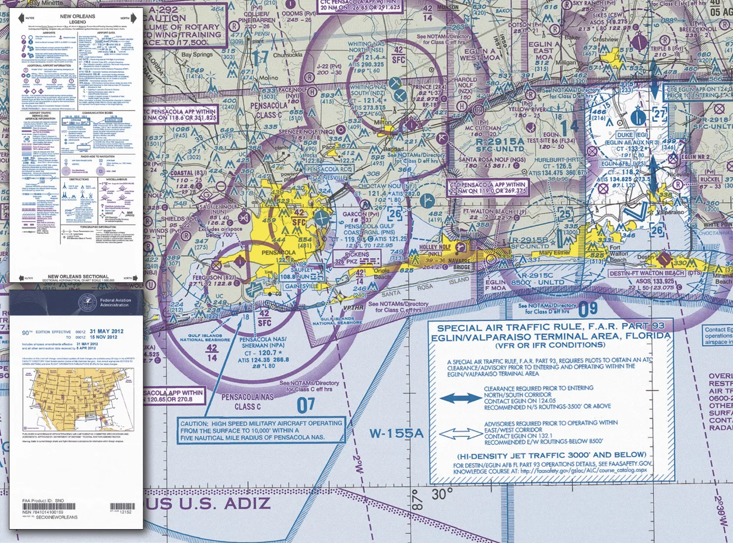
A Sectional Aeronautical Chart is the primary map for VFR pilots, named for the major city each sheet covers. Facts worth memorizing:
- Scale 1:500,000 — one inch on the chart equals about 6.86 NM
- Updated every 56 days — charts go stale; the FAA’s current cycle is what’s legally current
- At the test center you don’t get a full sectional — you get excerpts from the FAA Testing Supplement (CT-8080-2H), the same figures for everyone
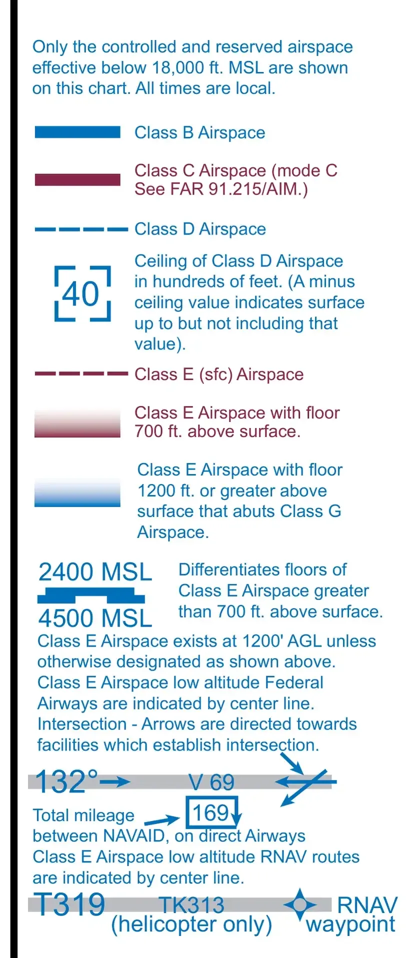 From the supplement you’ll use at the test center — the airspace panel of Legend 1. Every boundary symbol in this lesson, in exam-day form.
MSL vs AGL: The Conversion the Exam Keeps Testing
Charted altitude numbers are almost always MSL (mean sea level). Your drone rules are almost always AGL (above ground level). Every conversion is one subtraction:
AGL = MSL − ground elevation
- An airport at 250 ft elevation, Class D ceiling charted as
[29]→ 2,900 ft MSL − 250 ft = 2,650 ft AGL of Class D above that airport - Your 400 ft legal ceiling at the same spot = 650 ft MSL — you top out well inside the Class D (which is why you needed authorization in the first place)
- Terrain at 1,800 ft under a Class E floor of 7,000 ft MSL → the Class E floor is only 5,200 ft AGL over that ridge
The two systems appear in the same question on purpose. The charted floor of a Class B shelf is MSL. The 400-foot rule (14 CFR §107.51(b)) is AGL. “The shelf floor is 700 MSL and I’m at 400 AGL” is only answerable if you know the ground elevation — or if the question is testing whether you notice you can’t convert without it.
Reading Airspace Boundaries
Airspace boundaries show altitude information in a two-number format, charted in hundreds of feet MSL. The numbers often sit offset from the boundary itself with a leader line pointing to the segment they describe:
Top number / Bottom number
- Top number = ceiling (top of airspace) in hundreds of feet MSL
- Bottom number = floor (bottom of airspace) in hundreds of feet MSL
- SFC = surface (floor is the ground)
Examples
| Marker | Meaning |
|---|---|
| 100/SFC | Surface to 10,000 ft MSL — authorization required at any altitude |
| 40/SFC | Surface to 4,000 ft MSL — authorization required |
| 100/40 | 4,000 ft to 10,000 ft MSL — clear below 4,000 ft |
| 70/30 | 3,000 ft to 7,000 ft MSL — clear below 3,000 ft |
The FAA will show you 100/40 and ask if you can fly at 200 ft AGL. YES. The controlled airspace doesn’t start until 4,000 ft MSL. Below that floor is Class G.
Identifying Airspace on Charts
Class B — Solid Blue Concentric Circles
Look for solid blue circles around major airports (JFK, LAX, PHX). Multiple rings show different tiers. Inner rings reach the surface; outer rings are shelves with raised floors like 100/40 or 70/30.
Class C — Solid Magenta Concentric Circles
Solid magenta circles around medium-traffic airports. Usually two rings. The inner ring goes from the surface to 4,000 ft above airport elevation; the outer shelf typically starts no lower than 1,200 ft AGL.
Class D — Dashed Blue Circle
A dashed blue circle around a towered airport. Surface to 2,500 ft above airport elevation. Ceiling shown as a bracketed number like [25] — that’s MSL.
Class E Surface — Dashed Magenta Line
Dashed magenta lines mean Class E starting at the surface. Authorization required, same as Class D.
Class E (700 ft) — Soft Magenta Gradient
Soft magenta gradient = Class E starts at 700 ft AGL. Below 700 ft is Class G. Drone operations OK without authorization.
Class E (1200 ft) — Soft Blue Gradient
Soft blue gradient = Class E starts at 1,200 ft AGL. Below 1,200 ft is Class G. Drone operations OK.
Class G — Not Depicted
Everything not marked as something else is Class G. No authorization needed.
The Gradient Trick
When the FAA asks “what altitude does Class E begin?” look for the gradient:
- Soft magenta gradient → 700 ft AGL
- Soft blue gradient → 1,200 ft AGL

- No gradient and far from airports → 1,200 ft AGL (default)
- Dashed magenta line → Surface (authorization needed at all altitudes)
Worked Scenarios
These are the shapes the exam builds questions in. Walk each one aloud.
Scenario 1: Under the Shelf
A client’s site sits under the outer ring of a Class B, marked 100/40. Ground elevation is 600 ft. Can you fly the mission at 300 ft AGL?
- The shelf floor is 4,000 ft MSL.
- Ground is 600 ft MSL, so the shelf starts 3,400 ft above the ground.
- You’re at 900 ft MSL — 3,100 ft below the shelf, in Class G. Fly it. No authorization.
Scenario 2: The Rooftop in the Vignette
A rooftop inspection at 280 ft AGL inside soft magenta shading near a regional airport.
- Soft magenta = Class E with a 700 ft AGL floor.
- 280 ft AGL is 420 ft below the floor — Class G. No authorization.
- Same rooftop inside a dashed magenta surface area? Class E from the ground up — authorization required, full stop.
Scenario 3: The Bracket Math
A towered airport sits at 150 ft elevation with a dashed blue circle marked [28].
- Class D ceiling = 2,800 ft MSL.
- 2,800 − 150 = 2,650 ft AGL — consistent with the “2,500 ft above airport elevation, charted in MSL” pattern.
- Authorization covers you anywhere inside the dashed line, at any altitude, while the tower’s operating.
Scenario 4: The Edge Question
Your launch point sits under a Class C outer shelf segment marked 40/25. The floor is 2,500 ft MSL, and your 400 ft AGL flight (ground 900 ft MSL → 1,300 ft MSL) sits 1,200 ft below it, in Class G. The exam’s version of this question hinges on one thing: you read the bottom number, not the top. And remember that Class C outer shelves never reach the surface — if a “shelf” marker ends in SFC, you’re looking at a surface-area segment, not an outer ring.
Flight Hazards on and off the Chart (ACS II.B.K4)
The ACS expects you to know a set of flight hazards that live in the AIM’s safety-of-flight chapter — several appear in the chart itself, others only in NOTAMs or the world around you.
Unmanned Free Balloons
Unmanned research balloons can trail a suspension cable or wire antenna below them that is invisible until you’re close. The AIM’s instruction is unambiguous: aircraft “should remain well clear of all unmanned free balloons and flight below them should be avoided at all times” (¶7-6-5). Report any you sight to the nearest FAA facility.
Laser Operations
Laser light-show and research operations can appear via NOTAM near your flight area. Illumination “can create temporary vision impairment miles from the actual location” and can produce permanent eye damage (AIM ¶7-6-13). If a laser strikes you or your visual observer, report it to ATC or a Flight Service Station as soon as possible after the event.
Exhaust Plumes (Smokestacks and Cooling Towers)
Power plants and industrial sites vent hot, fast-moving exhaust that creates turbulence and vertical shear extending more than 1,000 ft above the top of the stack or tower (AIM ¶7-6-16). The hazard is worst in calm, cold air, and the plume may be invisible even when fully operating. The rule: fly the upwind side of smokestacks and cooling towers, and don’t judge risk by tower size.
Precipitation Static
Charged rain, snow, or dust particles strike an airframe and build a negative charge; when it discharges (“corona”) the result is radio noise and equipment weirdness — pilot reports include complete loss of VHF communications and magnetic compass errors up to 30 percent (AIM ¶7-6-12). For drone pilots it’s a reminder of why link degradation in precipitation is a real phenomenon, not a myth.
The Wire Environment
Transmission lines and their towers are charted on sectionals, but the wires between them are nearly invisible from the air and unlit at altitude. Low-level drone work — inspections, agriculture, real estate near ridgelines and river crossings — is flight in the wire environment. Treat every charted power line as a collision surface at unknown height, and give the towers’ span generous clearance.
Emergency Airborne Inspection
The ACS also names “emergency airborne inspection of other aircraft” (AIM ¶7-6-11) — a manned-aviation topic where a pilot in distress asks a nearby aircraft to inspect damage. Know the concept exists; the exam answer is that such inspection is done only with extreme caution, by agreement, when no alternative exists.
Key Facts to Walk In With
ACS Area II references: II.A.K1 (applied), II.B.K2, II.B.K3, II.B.K4b–g
- Sectional scale 1:500,000; 1 inch ≈ 6.86 NM; 56-day revision cycle
- Charted altitudes are MSL; convert with AGL = MSL − ground elevation
- Boundary format: top/bottom in hundreds of ft MSL; SFC = floor at the ground
- Magenta vignette = 700 ft AGL Class E floor; blue vignette = 1,200 ft
- Balloons: never fly beneath; plumes: stay upwind, effects can exceed 1,000 ft above the stack
- P-static: VHF loss and compass errors reported
Quick Check
Q: You see “100/SFC” inside a solid magenta circle. Can you fly at 200 ft AGL? A: No. The airspace extends from the surface to 10,000 ft. Authorization required at any altitude.
Q: You see “70/30” on a Class B shelf. Can you fly at 200 ft AGL? A: Yes. Controlled airspace starts at 3,000 ft MSL. Below that is Class G.
Q: What does a soft magenta gradient indicate? A: Class E starting at 700 ft AGL. Below 700 ft is Class G.
Q: An airport at 300 ft elevation has a Class D ceiling charted as [30]. How high is the Class D over the airport?
A: 2,700 ft AGL (3,000 MSL − 300 elevation), right at the typical 2,500-plus pattern.
Q: A cooling tower emits an invisible plume on a calm, cold morning. What do you do? A: Stay well clear, approach from the upwind side — turbulence can reach over 1,000 ft above the tower, and an invisible plume can still be fully operating.
What’s Next?
Next we’ll learn to read airport symbols, obstacle markers, and other critical symbols on sectional charts.
This free course covers the essential knowledge, but if you want video walkthroughs, practice exams, and instructor support, Pilot Institute’s Part 107 course is the most comprehensive option available.