Weather Briefings & Sources
A regulatory-compliant preflight briefing does not require a phone call: the AIM now states plainly that “pilots can receive a regulatory compliant briefing without contacting Flight Service” (¶7-1-5) — but whatever route you take must cover the same ground: adverse conditions, current weather, forecasts, winds aloft, and NOTAMs. This lesson is the map of sources and advisory products, ending with the go/no-go checklist that makes it a habit.
Where to Get Weather Information
Before every flight, Part 107 requires you to assess weather conditions. The primary sources:
1. Aviation Weather Center (aviationweather.gov)
- Official NOAA aviation weather
- METARs, TAFs, SIGMETs, AIRMETs, the Graphical Forecasts for Aviation (GFA) tool, winds aloft
- Free, comprehensive, always current
2. 1800wxbrief.com (Leidos Flight Service)
- The FAA’s flight service portal
- Standard, abbreviated, and outlook briefings by phone or online
- NOTAMs and TFR information alongside the weather — Flight Service remains a primary source for obtaining NOTAMs (AIM ¶7-1-5; ACS II.B.K5)
3. Flight Planning Apps (ForeFlight, Aloft, and similar)
- Weather, airspace, TFRs, NOTAMs in one interface
- Most Part 107 pilots use one daily; the data behind them is the same government feed
4. Automated Surface Observations (ASOS/AWOS)
- Automated stations at airports; broadcast on local frequencies (found in the Chart Supplement)
- Sensors sample continuously; routine reports issue hourly with SPECIs between
Any of the three briefing types — standard, abbreviated, outlook — satisfies the briefing requirement, and Flight Service specialists are FAA-certified Pilot Weather Briefers who translate forecasts into conditions along your route (AIM ¶7-1-5).
Types of Briefings
Standard Briefing
- The complete weather picture
- Use when: first briefing of the day, or more than 2 hours since the last one
- Includes (in the briefer’s sequence): adverse conditions, “VFR flight not recommended” if warranted, synopsis, current conditions, en route forecast, destination forecast, winds aloft, and NOTAMs
Abbreviated Briefing
- Supplemental update to a previous briefing
- Use when: you need specific information (say, just the current METAR at a nearby airport)
- Includes: what you ask for, plus any changes since the last briefing
Outlook Briefing
- Planning purposes, 6+ hours ahead
- Use when: scoping tomorrow’s job, not making today’s go/no-go
- Includes: general trends and expected conditions
The FAA tests which briefing type fits which situation. Standard = full picture, Abbreviated = update, Outlook = planning ahead. Also know: “VFR flight not recommended” is advisory — the AIM is explicit that “the final decision as to whether the flight can be conducted safely rests solely with the pilot.” For a drone pilot, that sentence is the remote-PIC responsibility doctrine in miniature.
Inflight Aviation Weather Advisories
Four advisory products warn of hazardous en route weather (AIM ¶7-1-6): the SIGMET, the Convective SIGMET, the AIRMET, and the Center Weather Advisory. All use VORs, airports, or geographic areas to describe the hazard area, and all heights are MSL except ceilings.
SIGMET (Significant Meteorological Information)
Severe, non-convective weather that affects all aircraft. Issued for:
- Severe icing not associated with thunderstorms
- Severe or extreme turbulence or CAT not associated with thunderstorms
- Widespread dust or sandstorms lowering visibility below 3 miles
- Volcanic ash
Valid up to 4 hours (6 hours for tropical cyclone and volcanic-ash SIGMETs). Designators run November through Yankee (Sierra and Tango are reserved for AIRMETs).
Convective SIGMET
The thunderstorm category, issued in the conterminous U.S. for:
- Severe thunderstorms — surface winds ≥ 50 knots, surface hail ≥ ¾ inch, or tornadoes
- Embedded thunderstorms
- A line of thunderstorms
- Thunderstorms with heavy precipitation over 40%+ of an area of at least 3,000 square miles
Two facts the exam likes: any Convective SIGMET implies severe-or-greater turbulence, severe icing, and low-level wind shear, and bulletins are issued hourly at H+55 with forecasts valid up to 2 hours.
AIRMET (Airmen’s Meteorological Information)
Weather at intensities lower than SIGMET criteria — aimed squarely at VFR pilots and lighter aircraft, which is exactly the drone category:
| Type | Covers |
|---|---|
| AIRMET Sierra | IFR conditions — ceiling below 1,000 ft and/or visibility below 3 SM — and widespread mountain obscuration |
| AIRMET Tango | Moderate turbulence, sustained surface winds > 30 knots, non-convective low-level wind shear below 2,000 ft AGL |
| AIRMET Zulu | Moderate icing and freezing level heights |
AIRMETs issue every 6 hours over the contiguous U.S. (every 8 in Alaska); the graphical AIRMETs on aviationweather.gov extend the forecast to 12 hours in discrete steps no more than 3 hours apart.
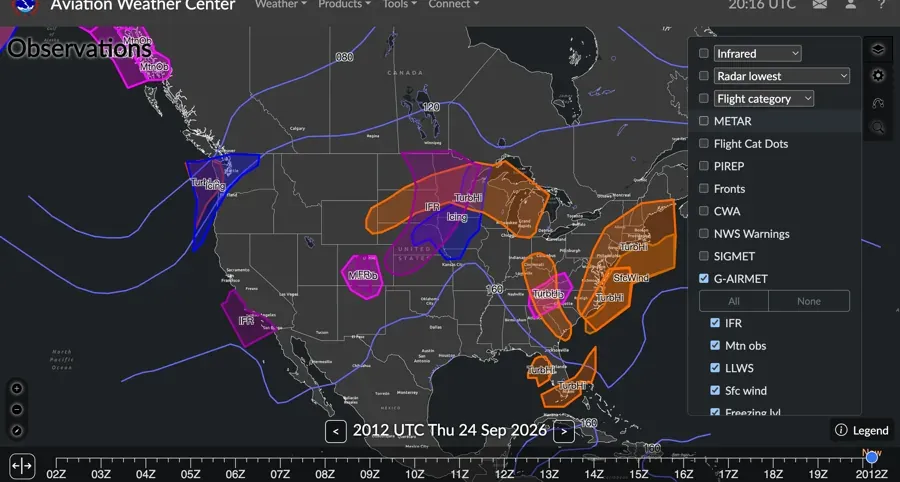 Graphical AIRMETs on the GFA tool: the same advisory the text product gives you, drawn on the map you’ll actually fly over — out to 12 hours.
AIRMETs matter MORE for drone pilots than SIGMETs, because AIRMETs specifically address conditions that affect light aircraft. Tango (turbulence/wind/wind shear) and Sierra (low ceilings/visibility) are the two that map directly onto §107.51 minimums — an AIRMET Sierra for visibilities below 3 SM is literally your legal limit being forecast.
Wind Charts

- Wind speed and direction at altitude, depicted with wind barbs
- Short barb = 5 knots, long barb = 10 knots, pennant = 50 knots

You fly in the surface wind, but the winds aloft preview your afternoon: strong winds aloft mix down during daytime heating, and the surface gusts at 2 PM were often the 3,000-ft wind at 9 AM.
Making the Go/No-Go Decision
Before every flight, in order:
- Current METAR at the nearest airport: visibility, wind, clouds, temp/dewpoint spread
- TAF: what’s forecast for your operating window — including the TEMPO groups
- AIRMETs / SIGMETs / Convective SIGMETs: any advisory touching your area?
- TFRs and NOTAMs: any airspace restrictions? (Flight Service or your app — never skip it)
- Local conditions: what you see out the window is the final source of truth
If the METAR shows conditions at or near Part 107 minimums (3 SM visibility, low clouds, closing spread), don’t fly. Conditions deteriorate faster than a drone lands — and the spread shrinking toward zero is the early warning.
Key Facts to Walk In With
ACS references: III.A.K1, K4–K5; II.B.K5
- Briefing types: Standard / Abbreviated / Outlook; self-briefing is regulatory-compliant (AIM ¶7-1-5, AC 91-92)
- “VFR not recommended” is advisory; the go/no-go decision is the pilot’s alone
- SIGMET: severe non-convective; 4 hr (6 for tropical cyclone/ash)
- Convective SIGMET: TS criteria ≥50 kt / ¾” hail / tornado / lines / embedded; hourly H+55; 2-hr validity; implies severe turbulence + icing + LLWS
- AIRMET S/T/Z: IFR-mountain obscuration / turbulence-wind-LLWS / icing-freezing level; every 6 hr, graphical to 12 hr
- NOTAMs: available through Flight Service, 1800wxbrief, and apps
Quick Check
Q: What are the three types of weather briefings? A: Standard (complete), Abbreviated (update), Outlook (planning).
Q: What does an AIRMET Tango cover? A: Moderate turbulence, sustained surface winds above 30 knots, and non-convective low-level wind shear below 2,000 ft AGL.
Q: How long is a SIGMET valid? A: Up to 4 hours — 6 for tropical cyclones and volcanic ash.
Q: A Convective SIGMET is issued for your area. What three hazards does it imply even without saying so? A: Severe or greater turbulence, severe icing, and low-level wind shear.
Q: The briefer says “VFR flight not recommended.” Are you legally grounded? A: No — the statement is advisory. The go/no-go decision rests solely with the pilot in command.
Q: How can you obtain NOTAMs for your flight? A: Through Flight Service (1800wxbrief.com), flight planning apps, or the online NOTAM system — the ACS names Flight Service as the classic route.
What’s Next?
Weather section complete. Now we move into loading, performance, and aerodynamics: how your drone flies and what limits its capabilities.
This free course covers the essential knowledge, but if you want video walkthroughs, practice exams, and instructor support, Pilot Institute’s Part 107 course is the most comprehensive option available.