Airport Operations
Everything at an airport is color-coded, and the code is the exam: white runway markings against yellow taxiway lines, red mandatory signs against yellow location signs, blue taxiway lights against white runway edges, and a beacon whose color pair tells you what kind of field you’re near. Drone pilots rarely use runways — but you operate beside them, under their traffic patterns, and occasionally inside their security perimeters, so the ACS makes airport literacy a tested Area V skill.
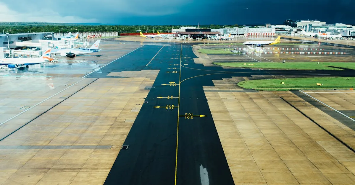
Types of Airports
Towered (Controlled)
- An operating ATC tower; blue on sectional charts
- Pilots must communicate with ATC; drone operations need §107.41 authorization
Non-Towered (Uncontrolled)
- No tower; magenta on sectionals
- Pilots self-announce on CTAF; drones may still need authorization depending on underlying airspace
The chart color tells you about the tower, not the airspace. A magenta airport can sit inside a Class E surface area that requires authorization just the same.
Runway Numbering
Runway numbers are magnetic heading ÷ 10, rounded (AIM ¶2-3-3):
- Runway 9 ≈ 090° magnetic (east); Runway 27 ≈ 270° (west)
- 9 and 27 are the same pavement from opposite ends
- Parallel runways take L/C/R suffixes
Final approach to Runway 9 = heading east. The exam’s trick version gives you one runway number and asks the magnetic heading of the opposite end — it’s your number ± 18.
Runway Markings
Basic Markings (Non-Towered Fields)
- Runway designation numbers at each end
- Centerline: dashed white line
- Threshold markings: stripes at the runway ends
Precision Instrument Markings
All of the above, plus:
- Touchdown zone markers: paired stripes at set intervals
- Aiming point markers: broad blocks near each touchdown zone
- Taxiway markings: yellow — runway markings are always white
Airport Signs and Lighting
Signs
- Runway holding position sign: red panel with white text (“9-27”) — a mandatory hold point; do not cross without clearance
- Taxiway direction sign: yellow panel with black text and arrow
- Location sign: black panel with yellow text and yellow border — “you are here”
Red-with-white = mandatory instruction. Yellow-with-black = location/direction. The exam swaps the color schemes in the wrong answers.
Lighting
- Runway edge lights: white (amber near the last 2,000 ft of the approach end on precision runways)
- Taxiway edge lights / centerline: blue edges, green centerline
- Approach lighting systems: configurations sequenced to the threshold at instrument-equipped fields
The Airport Beacon (AIM ¶2-1-9)
| Beacon colors | Marks |
|---|---|
| White and green | Lighted land airport |
| White and yellow | Lighted water airport |
| Green, yellow, and white | Lighted heliport |
Military beacons flash white-green with a dual-peaked (double-flash) white. And a fact the exam likes: in Class B/C/D and E surface areas, a beacon running during daylight hours often means visibility below 3 miles and/or ceiling below 1,000 feet — weather worth noting before you even pull the drone out.
Traffic Patterns
Manned aircraft fly standardized patterns around runways (AIM ¶4-3-3):
- Upwind leg: parallel to the runway, climbing after departure
- Crosswind leg: perpendicular, after leaving the departure end
- Downwind leg: parallel and opposite to landing direction, typically at 1,000 ft AGL
- Base leg: perpendicular, turning toward final
- Final approach: aligned with the runway, descending

Stay below pattern altitude and clear of the approach/departure paths near any airport. A drone at 380 ft under a 1,000-ft pattern is legal and unremarkable to manned pilots; the same drone drifting into the final approach course at 400 ft is a midair waiting for a date.
Drone Positioning Near a Pattern
Three positioning rules keep you out of the pattern’s conflicts:
- Operate on the opposite side of the runway from the pattern legs when the site allows — the traffic lives on the left side (standard patterns are left-hand unless the Chart Supplement says right), so the right side of the extended centerline is the quiet half
- Stay outside the extended centerlines — the final approach path and the departure corridor are the two places aircraft are guaranteed to be, descending or climbing through exactly the altitudes drones like
- Listen while you work: a scanner on CTAF tells you which runway is active and how far out traffic is — pattern turns are announced (“midfield left downwind two-six”), and those calls are your early-warning grid
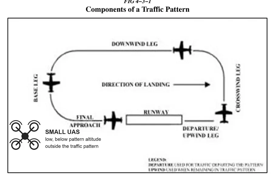 The pattern from the drone’s side of the fence: below 1,000 ft, outside the centerlines, opposite the pattern legs.
The Segmented Circle (AIM ¶4-5-2)
At non-towered fields, the segmented circle is the ground-side pattern briefing system — a circular marker, centered on:
- A wind cone/sock (or wind tee): the large end points into the wind
- A tetrahedron: the small end points in the landing direction — and the AIM cautions pilots against using it for wind direction or calm-wind runway selection
For drone pilots: the wind sock beside a segmented circle is the best free, real-time wind reading at any small airport — more local than the METAR, updated every second.
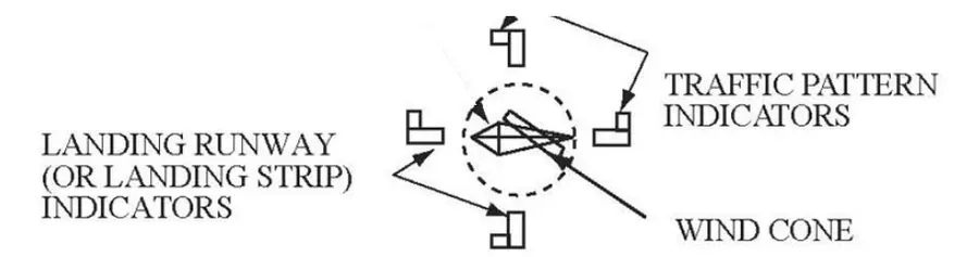 Wind sock large end into the wind; tetrahedron small end toward landing. Two questions, two answers, one glance.
Security Areas: SIDA (V.B.K5)
A Security Identification Display Area is the portion of a commercial-service airport — under 49 CFR part 1542 — where access requires a security badge and escort for visitors: ramps, baggage areas, air operations areas. If your drone job touches an airport property (airline contract work, ramp inspections), you’re entering a SIDA, which means badging, escort procedures, and zero unescorted wandering. Operating a drone near or inside a SIDA without coordination isn’t just an FAA issue — it’s a security violation with its own enforcement track.
Wildlife Hazards (V.B.K7)
Airports attract birds — open ground, short grass, standing water — and manage them intensively (the FAA’s wildlife hazard program, AC 150/5200-32). Birds and drones collide on surprisingly even terms: a gull through a prop is a crash. Around airports, expect concentrated bird activity at dawn and dusk, near ponds and short-grass areas, and during migration seasons — and remember the manned traffic you’re avoiding shares the same birds at higher closure rates.
Wake Turbulence (AIM ¶7-3)
Behind every large aircraft trails a pair of counter-rotating vortices off the wingtips — invisible, sinking, drifting with the wind, and violent enough to flip a small aircraft. The drone-relevant facts:
- Vortices sink and drift; they linger for minutes after the generating aircraft has gone
- The hazard zones are behind and below departing/arriving heavy aircraft — exactly where a low drone near a runway would sit
- Helicopters produce their own downwash/outwash that can toss a small UAS at surprising distances
Practical rule: near runways serving anything bigger than light twins, wait out arrivals and departures before crossing the extended runway paths — a minute of patience beats a drone in a vortex.
The Chart Supplement (V.B.K6b)
The Chart Supplement holds the detail the chart can’t: field elevation, runway dimensions and surfaces, traffic pattern altitude and direction (which runways are right traffic), all frequencies (CTAF, tower, ground, ATIS/ASOS), fuel and services, operating hours, and the remarks that change missions (part-time towers, noise procedures, “UAS ops” notes).
Which source answers which question: sectional = airspace and symbols; Chart Supplement = procedures, hours, pattern direction; NOTAMs = what changed today. The exam sends you to the right book by the question’s noun.
Key Facts to Walk In With
ACS references: V.B.K1–K8
- Runway number = magnetic azimuth ÷ 10; opposite end ± 18
- Runway markings white, taxiway yellow; red signs mandatory; taxiway edge lights blue
- Beacon: W/G land, W/Y water, G/Y/W heliport; daytime beacon = likely IFR weather
- Pattern legs and typical 1,000-ft AGL downwind; stay below and clear
- Segmented circle: wind sock large end into wind; tetrahedron small end = landing direction
- SIDA: badged/escorted security areas (49 CFR 1542)
- Wake: behind-and-below heavy aircraft; vortices sink and linger
Quick Check
Q: Runway 18 points in which direction? A: South — approximately 180° magnetic.
Q: What color are taxiway edge lights? A: Blue.
Q: What does a red sign with white text indicate? A: A mandatory instruction — typically a runway holding position; do not proceed without clearance.
Q: The beacon at a Class D airport is on at 2 PM, clear day. What might that mean? A: Below 3 miles visibility and/or ceiling under 1,000 feet — check the weather before flying.
Q: Which part of a tetrahedron points the landing direction? A: The small end — and it indicates landing direction only, never wind.
Q: Where’s the worst place for a drone when a bizjet departs? A: Behind and below its flight path — in the sinking, drifting wingtip vortices.
What’s Next?
Now let’s learn about radio communications: frequencies, the phonetic alphabet, and how to communicate near airports.
This free course covers the essential knowledge, but if you want video walkthroughs, practice exams, and instructor support, Pilot Institute’s Part 107 course is the most comprehensive option available.