Special Use Airspace
Special use airspace is where the FAA contains activity that is hazardous to nonparticipating aircraft or needs separating from normal traffic: prohibited and restricted areas, military operations areas, alert and warning areas, controlled firing areas, and national security areas, plus the military training routes that thread between them. For authorization purposes only two matter — prohibited areas (never, under any circumstances) and restricted areas (only with permission from the controlling agency). Everything else is legal to fly with caution and a status check.
Why Special Use Airspace Matters
Beyond the Class A–G system, the FAA designates special use airspace (SUA) where “flight activities must be confined because of their nature” or where limitations are imposed on aircraft that aren’t part of those activities. The FAA tests these areas directly — expect restricted/prohibited questions and at least one military training route question.
What Is a Prohibited Area?
- P- designation (P-56 around the White House, P-40 around Camp David)
- Flight of aircraft is prohibited — established for security or national-welfare reasons (AIM ¶3-4-2)
- Shown as blue hatched areas on sectional charts
- Regulated under 14 CFR Part 73

Prohibited areas are absolute no-fly zones. If the FAA shows you one on a chart and asks if you can fly there, the answer is always no — no waivers, no permission procedure, no exceptions.
What Is a Restricted Area?
- R- designation (R-2306, R-2508, etc.)
- Contains “unusual, often invisible, hazards to aircraft such as artillery firing, aerial gunnery, or guided missiles” (AIM ¶3-4-3)
- Flight is not wholly prohibited, but subject to restrictions — you need permission from the using or controlling agency
- Shown as blue hatched areas with the R- designation
- Regulated under 14 CFR Part 73

Unlike prohibited areas, restricted areas CAN be flown in — but only with permission from the using/controlling agency. ATC is not that agency. Some restricted areas are “joint-use”: when inactive and released back to the FAA, ATC can route IFR traffic through, but that’s their clearance, not yours.
Restricted Area Information
The margins of each sectional chart include a table listing special use areas with:
- Area designation (R-2306A)
- Controlling agency (who to contact for permission)
- Altitude limits (surface to X,000 ft)
- Operating hours (times when the restriction is active)
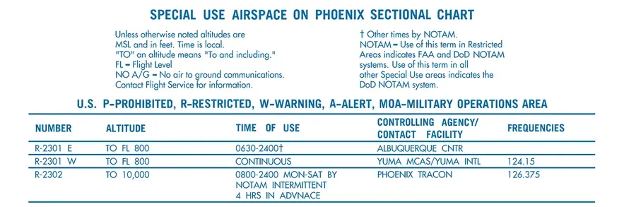 The chart’s own SUA table: controlling agency, altitudes, and hours for every restricted area on the sheet. ‘NOTAM’ in the time column means check current NOTAMs before trusting the schedule.
A restricted area with “NOTAM” in the time column means the hours vary — you have to check current NOTAMs to know whether it’s hot.
What Is a Warning Area?
- Airspace of defined dimensions extending from 3 NM outward from the U.S. coast (AIM ¶3-4-4)
- Contains activity that “may be hazardous to nonparticipating aircraft” — think live-fire and fleet exercises
- May sit over domestic waters, international waters, or both

What Is a Military Operations Area (MOA)?
- Magenta hatched areas with names like “Rainbow MOA” or “Gila MOA”
- Established “for the purpose of separating certain military training activities from IFR traffic” (AIM ¶3-4-5)
- Activities include air combat tactics, air intercepts, aerobatics, formation training, and low-altitude tactics
- Military pilots may exceed 250 knots below 10,000 ft MSL inside an active MOA
- VFR flight — and drone flight — is not prohibited, but the AIM’s own word is to “exercise extreme caution”

How Do You Check Whether a MOA Is Active?
MOA status changes frequently. AIM ¶3-4-9 lists the sources:
- The using or controlling agency — frequencies are tabulated in the chart margins
- Any Flight Service Station within 100 miles of the area, for real-time hours of operation
- ARTCC NOTAMs — airspace activation NOTAMs get issued for SUA
- The FAA’s Special Use Airspace website, for scheduling data during preflight planning
You are allowed to fly in MOAs without anyone’s permission. The exam answer is “exercise extreme caution” — and know that the military may be flying fast and low with a regulatory exemption to do it.
What Is an Alert Area?
- Magenta hatched areas with A- designation (A-231, etc.)
- Marks a “high volume of pilot training or an unusual type of aerial activity” (AIM ¶3-4-6)
- Not restricted — all activity inside must comply with the CFRs “without waiver,” and everyone (participants and transiting aircraft) shares equal responsibility for collision avoidance

What Is a Controlled Firing Area (CFA)?
The odd one out: CFAs contain hazardous activities — ordnance disposal, for example — but activities are suspended immediately any time spotter aircraft, radar, or ground lookouts detect a nonparticipating aircraft approaching (AIM ¶3-4-7). Because the hazard stands down for you, CFAs are not charted and require nothing from you. The exam likes testing that a CFA is the special use airspace that does not appear on your sectional.
What Is a National Security Area (NSA)?
- Depicted with dashed magenta lines at locations requiring “increased security and safety of ground facilities” (AIM ¶3-4-8)
- Pilots are requested to voluntarily avoid flying through — it’s a request, not a restriction, by default
- The FAA can temporarily make an NSA mandatory via 14 CFR §99.7 special security instructions, disseminated by NOTAM
Military Training Routes (MTRs)
Low-level, high-speed military routes — “generally established below 10,000 feet MSL for operations in excess of 250 knots” (AIM ¶3-5-2). They’re charted as gray lines with route identifiers, and the identifier encodes the hazard:
- IR routes are flown under IFR regardless of weather; VR routes are flown under VFR, with visibility of at least 5 statute miles and ceilings no lower than 3,000 ft AGL
- Four-digit numbers (IR1206, VR1207) = no segment of the route above 1,500 ft AGL — these stay low, which is why they matter most to drone pilots
- Three-digit numbers (IR206, VR207) = one or more segments above 1,500 ft AGL
- A letter suffix (IR008A) marks an alternate route or segment

Memory hook: four digits, feet low — a 4-digit IR/VR route never leaves the low-altitude regime below 1,500 ft AGL. Three digits means the route climbs above it somewhere.
Temporary Flight Restrictions (TFRs)
TFRs are dynamic restrictions issued by NOTAM, not charted airspace. They exist to protect people and property from hazards (14 CFR §91.137), disaster relief aircraft, the President and other public figures (§91.141), and space operations (§91.143). The drone-relevant examples:
- Wildfires — never fly near firefighting operations; TFRs appear fast and penalties are real
- Presidential/VIP movements — the largest and least predictable
- Stadium sporting events — a 3 NM radius from the center of the event, up to 2,500 ft above the surface (14 CFR §91.145). The rule names the World Series, All-Star Game, Indy 500, and similar events, and the FAA issues standing seasonal TFRs around NFL, MLB, and major college football games
- Disaster areas and space launch/recovery zones
ALWAYS check for TFRs before flying. A TFR can be issued at any time and makes otherwise legal airspace temporarily restricted. The AIM’s UAS chapter is blunt: “substantial fines and penalties can be levied on UAS remote pilots” who violate one. Check 1800wxbrief.com, the FAA’s TFR list, or your flight planning app — every flight.
Terminal Radar Service Areas (TRSAs)
A TRSA is a radar-service area around selected busy airports, charted with a solid black line and segment altitudes. Here’s the part the exam tests: a TRSA is not controlled airspace — it “does not fit into any of the U.S. airspace classes” (AIM ¶3-5-6). The primary airport inside is Class D (that part does require authorization); the rest of the TRSA overlying Class E is voluntary participation radar service for manned VFR traffic. For a drone pilot: read the chart, ignore the black line’s shape, and authorize against the underlying class.
Special Flight Rules Areas (SFRAs)
Airspace where flight is subject to rules set out in 14 CFR Part 93 — the Washington DC SFRA is the famous one, wrapped around the DC Flight Restricted Zone. SFRAs are charted with distinctive boundaries (the DC one shows its own cutouts and gates). If you fly near the nation’s capital, the SFRA and FRZ rules dwarf everything else on the chart — drone operations there are effectively forbidden without specific federal authorization.
Other Airspace You’ll See
Published VFR Routes
VFR flyways — general flight paths for planning around and under complex terminal airspace like Class B shelves — do not require an ATC clearance (AIM ¶3-5-5). They’re depicted on VFR Flyway Planning Charts. The stricter variants (VFR transition routes, Class B VFR corridors) may require a clearance; the chart annotation tells you which you’re looking at.
Parachute Jump Areas
Shown on sectional charts with parachute symbols. Not restricted, but a jump area in active use is the definition of a place you don’t want to be — jumpers descend fast and silently.
Key Facts to Walk In With
ACS Area II references: II.A.K2, II.A.K3
- Prohibited (P-): never, no procedure
- Restricted (R-): permission from the using/controlling agency
- Warning: 3 NM+ offshore from the coast
- MOA: legal to fly, extreme caution, status via FSS within 100 NM
- Alert (A-): high-volume training, no restriction
- CFA: hazard suspends when nonparticipants approach; not charted
- NSA: voluntary avoidance; can go mandatory via §99.7 NOTAM
- MTRs: IR = IFR; VR = VFR (5 SM vis, 3,000 ft ceiling); 4 digits = stays ≤1,500 ft AGL
- Stadium TFR: 3 NM radius, up to 2,500 ft above the surface (§91.145)
- TRSA: solid black line, not controlled airspace, Class D core
Quick Check
Q: Can you fly in a Restricted Area? A: Only with permission from the using or controlling agency — not ATC.
Q: What about an MOA — is flying prohibited? A: No. MOAs are not restricted. You can fly there, but exercise extreme caution and check whether the MOA is active first.
Q: Which special use airspace is NOT shown on sectional charts? A: Controlled Firing Areas — activities stand down when nonparticipating aircraft approach, so there’s nothing for you to avoid.
Q: Route VR1103 crosses your site. Why care more than about VR103? A: VR1103 has four digits — no segment above 1,500 ft AGL. The whole route lives in the low-altitude regime where your drone flies.
Q: What are the dimensions of a stadium TFR? A: Normally a 3 NM radius from the center of the event, up to 2,500 ft above the surface, per 14 CFR §91.145.
Q: You see a solid black line around an airport on a sectional. What is it? A: A TRSA — terminal radar service, which is voluntary and not controlled airspace. Authorize against the underlying class (the Class D core, most likely).
What’s Next?
Now let’s learn to read all this airspace information on sectional charts. This is the single most tested skill on the exam.
This free course covers the essential knowledge, but if you want video walkthroughs, practice exams, and instructor support, Pilot Institute’s Part 107 course is the most comprehensive option available.