METARs & TAFs
Why You Need to Read Weather Reports
The FAA expects you to check weather before every flight. Aviation weather reports (METARs) and forecasts (TAFs) are the standard format. The exam tests your ability to decode them.
METAR — Current Weather
METAR stands for Meteorological Aerodrome Report. It’s a snapshot of current weather conditions at an airport.
METAR Format
METAR KPHX 261755Z 27010KT 10SM FEW050 SCT100 BKN250 30/15 A2992Here’s how to read it, piece by piece:
| Section | Example | Meaning |
|---|---|---|
| Type | METAR | Routine report (SPECI = special/unscheduled) |
| Station | KPHX | Phoenix Sky Harbor (ICAO code) |
| Date/Time | 261755Z | 26th day, 17:55 Zulu (UTC) |
| Wind | 27010KT | From 270 degrees at 10 knots |
| Visibility | 10SM | 10 statute miles |
| Clouds | FEW050 SCT100 BKN250 | Few at 5,000 ft, Scattered at 10,000 ft, Broken at 25,000 ft |
| Temp/Dewpoint | 30/15 | 30 degrees C temperature, 15 degrees C dewpoint |
| Altimeter | A2992 | 29.92 inHg |

Wind Coding
27010KT= from 270 degrees at 10 knots27010G20KT= from 270 degrees at 10 knots, gusting to 20 knotsVRB05KT= variable at 5 knots (no specific direction)00000KT= calm (no wind)
“G” means gusting. “VRB” means variable direction. Wind is always reported as the direction the wind is coming FROM, referenced to true north (not magnetic).
Visibility Coding
10SM= 10 statute miles3SM= 3 statute miles (the Part 107 minimum)1/2SM= half a statute mileP6SM= greater than 6 statute miles
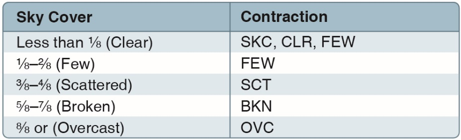
Cloud Coverage
| Abbreviation | Meaning | Coverage |
|---|---|---|
| SKC or CLR | Clear | 0/8 |
| FEW | Few | 1/8 to 2/8 |
| SCT | Scattered | 3/8 to 4/8 |
| BKN | Broken | 5/8 to 7/8 |
| OVC | Overcast | 8/8 (full coverage) |
The number after the coverage abbreviation is the cloud base height in hundreds of feet AGL:
FEW050= few clouds at 5,000 ft AGLBKN030= broken clouds at 3,000 ft AGLOVC010= overcast at 1,000 ft AGL
Cloud heights in METARs are AGL, not MSL. Sectional charts use MSL. The exam will try to trip you up on this distinction.
Weather Phenomena
Common codes you’ll see in METARs:
| Code | Meaning |
|---|---|
| BR | Mist (visibility 5/8 SM to 6 SM) |
| FG | Fog (visibility less than 5/8 SM) |
| HZ | Haze |
| RA | Rain |
| SHRA | Rain showers |
| TSRA | Thunderstorm with rain |
| SN | Snow |
| -RA | Light rain |
| +RA | Heavy rain |
TAF — Terminal Aerodrome Forecast
TAF stands for Terminal Aerodrome Forecast. It covers the area around an airport and is valid for 24 to 30 hours.
TAF Format
TAF KPHX 261700Z 2618/2718 27010KT P6SM SCT100


TEMPO 2618/2622 27015G25KT 5SM TSRA BKN030CB- Same format as METAR for basic conditions
TEMPO= temporary (expected for less than 1 hour at a time)BECMG= becoming (transition to new conditions)FM= from (new time period with different conditions)PROB30/PROB40= probability (30% or 40% chance)
TEMPO means the condition is temporary, lasting less than 1 hour. The FAA tests whether you know the difference between TEMPO and BECMG.
Quick Check
Q: In a METAR, what does BKN030 mean?
A: Broken clouds (5/8 to 7/8 coverage) at 3,000 ft AGL.
Q: Wind is reported as 27010G20KT. What does this mean? A: Wind from 270 degrees at 10 knots, gusting to 20 knots.
Q: What does TEMPO mean in a TAF? A: Temporary. The condition is expected to last less than 1 hour at a time.
What’s Next?
Now let’s learn where to get weather briefings and how to interpret the bigger picture: SIGMETs, AIRMETs, and official weather sources.
This free course covers the essential knowledge, but if you want video walkthroughs, practice exams, and instructor support, Pilot Institute’s Part 107 course is the most comprehensive option available.