Airspace Classification
Why Airspace Matters for Drone Pilots
Airspace classification determines whether you can fly in a given area and whether you need authorization. This is the second most tested topic on the Part 107 exam (15-25% of questions). Every question ties back to knowing which class you’re in.
The FAA divides airspace into two categories:
- Controlled airspace — ATC services available, authorization required for drones
- Uncontrolled airspace — no ATC oversight, drone pilots can operate freely (within Part 107 rules)
The Two Categories
Controlled Airspace
- Class A, B, C, D, E — you need authorization (LAANC or manual approval) to fly here
- ATC provides separation services to manned aircraft
- Drone pilots must obtain permission before operating
Uncontrolled Airspace
- Class G — no authorization needed (this is where most drone flights happen)
- No ATC services
- Most of the US land area is Class G near the surface
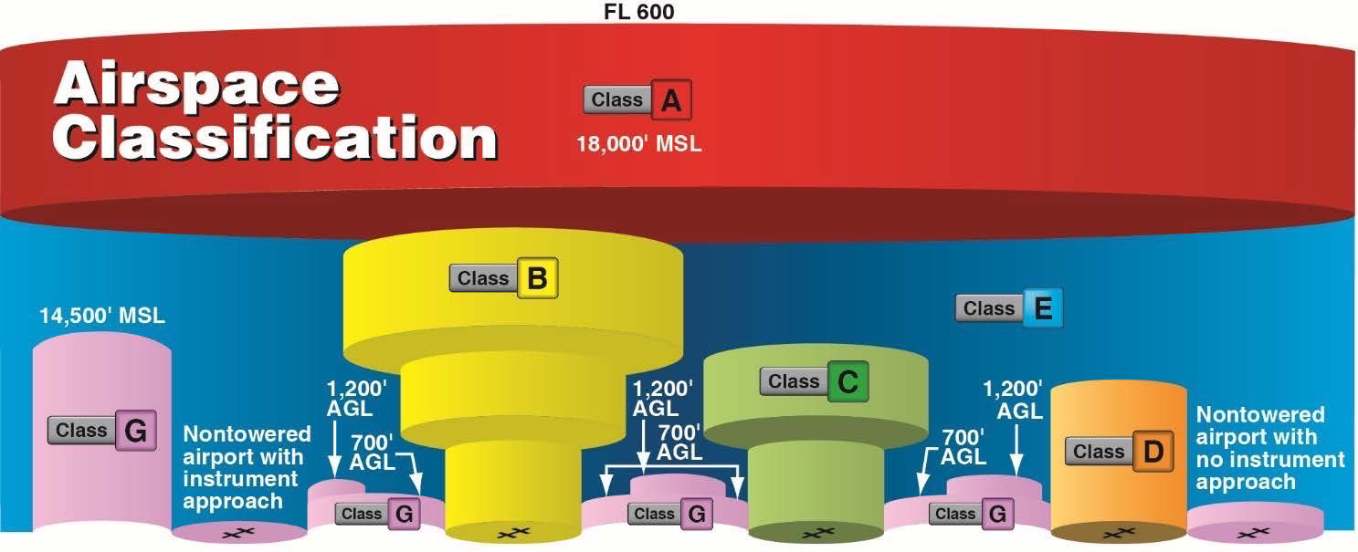
Class A Airspace
- Altitude: 18,000 ft MSL up to FL600 (60,000 ft)
- Not relevant for drone pilots — way above our operating altitude
- Instrument Flight Rules (IFR) only, no VFR operations
- You will never legally operate a Part 107 drone in Class A
Class B Airspace
- Around the busiest airports (JFK, LAX, PHX, ATL, about 37 airports nationwide)
- Looks like an upside-down wedding cake with multiple concentric layers
- Inner layer: surface to typically 10,000 ft MSL
- Outer layers: progressively higher floors (1,000 ft, 2,000 ft, etc.)
- Drone operations require ATC authorization
Class B is shown as solid blue circles on sectional charts. If you see solid blue, think “Big, Busy, Blue.” Major airports, strictest rules.
Class C Airspace
- Around moderately busy airports with control towers and radar service
- Two concentric circles:
- Inner ring: surface to typically 4,000 ft AGL
- Outer ring: typically 1,200 ft AGL to 4,000 ft AGL
- Drone operations require ATC authorization
Class C is solid magenta circles on sectional charts. “C” for “City.” Medium cities with towered airports.
Class D Airspace
- Around towered airports with lower traffic volume
- Single area: surface to typically 2,500 ft AGL (shown as a bracketed number)
- Drone operations require ATC authorization
Class D is a dashed blue circle on sectional charts. “D” for “Dashed.” Look for the blue dashes around the airport.
Class E Airspace
The catch-all for controlled airspace. Exists in several forms:
Class E Surface Area
- Dashed magenta line around an airport
- Extends from the surface up to the overlying controlled airspace
- Authorization required
Class E at 700 ft AGL
- Soft magenta gradient (feathered edge) on sectional charts
- Below 700 ft AGL = Class G (no authorization needed)
- Above 700 ft = Class E (authorization required)
- Most of the eastern US has this pattern
Class E at 1,200 ft AGL
- Soft blue gradient on sectional charts (or no gradient at all in some areas)
- Below 1,200 ft AGL = Class G
- Above 1,200 ft = Class E
- Common in the western US
If you’re flying at 400 ft AGL and you see soft magenta shading, you’re in Class G. The controlled airspace doesn’t start until 700 ft. You’re fine. If you see soft blue shading, you’re also fine. Controlled airspace there doesn’t start until 1,200 ft.
Class G Airspace
- Uncontrolled, no ATC authorization needed
- Not depicted on sectional charts (it’s the absence of other markings)
- Where most Part 107 operations occur
- Still must follow all Part 107 rules (400 ft, VLOS, etc.)
Class G is where you can fly freely. Every other class requires some form of authorization.
Airspace Summary Table
| Class | Shape on Chart | Color | Auth Required? |
|---|---|---|---|
| B | Solid concentric circles | Blue | Yes |
| C | Solid concentric circles | Magenta | Yes |
| D | Dashed circle | Blue | Yes |
| E (surface) | Dashed line | Magenta | Yes |
| E (700 ft) | Soft gradient | Magenta | Below 700 = No |
| E (1200 ft) | Soft gradient | Blue | Below 1200 = No |
| G | Not depicted | — | No |
Quick Check
Q: What color are Class B airspace circles on a sectional chart? A: Solid blue.
Q: You see soft magenta shading on the chart. If you fly at 400 ft AGL, do you need authorization? A: No. The soft magenta means Class E starts at 700 ft. Below that is Class G.
Q: Which airspace class covers most of the US near the surface? A: Class G. It’s everywhere that isn’t specifically designated as something else.
What’s Next?
Now that you know the airspace classes, let’s look at special use airspace: restricted areas, prohibited areas, MOAs, and TFRs.
This free course covers the essential knowledge, but if you want video walkthroughs, practice exams, and instructor support, Pilot Institute’s Part 107 course is the most comprehensive option available.