Airspace on Sectional Charts
The Most Tested Skill on the Exam
Reading airspace on sectional charts is the single most tested skill on the Part 107 exam. Expect 12-18 questions requiring you to read a chart excerpt, identify airspace class, locate boundaries, and interpret altitude markers.
Sectional Chart Basics
A Sectional Aeronautical Chart is the primary map for VFR pilots. For drone operators, it answers three questions:
- Where can I fly? — what airspace class am I in?
- How high can I fly? — are there altitude floors above me?
- What hazards exist? — towers, restricted areas, airports nearby?
The FAA publishes 37 sectionals covering the continental US, updated every 56 days. Scale is 1:500,000 (1 inch = 6.86 nautical miles).
Reading Airspace Boundaries
Airspace boundaries show altitude information using a two-number format:
Top number / Bottom number
- Top number = ceiling (top of airspace) in hundreds of feet MSL
- Bottom number = floor (bottom of airspace) in hundreds of feet MSL
- SFC = surface (floor is the ground)
Examples
| Marker | Meaning |
|---|---|
| 100/SFC | Surface to 10,000 ft MSL — authorization required at any altitude |
| 40/SFC | Surface to 4,000 ft MSL — authorization required |
| 100/40 | 4,000 ft to 10,000 ft — clear below 4,000 ft |
| 70/30 | 3,000 ft to 7,000 ft — clear below 3,000 ft |
The FAA will show you 100/40 and ask if you can fly at 200 ft AGL. YES. The controlled airspace doesn’t start until 4,000 ft MSL. Below that is Class G.
Identifying Airspace on Charts
Class B — Solid Blue Concentric Circles
Look for solid blue circles around major airports (JFK, LAX, PHX). Multiple rings show different tiers. Inner rings have lower floors, outer rings have higher floors.
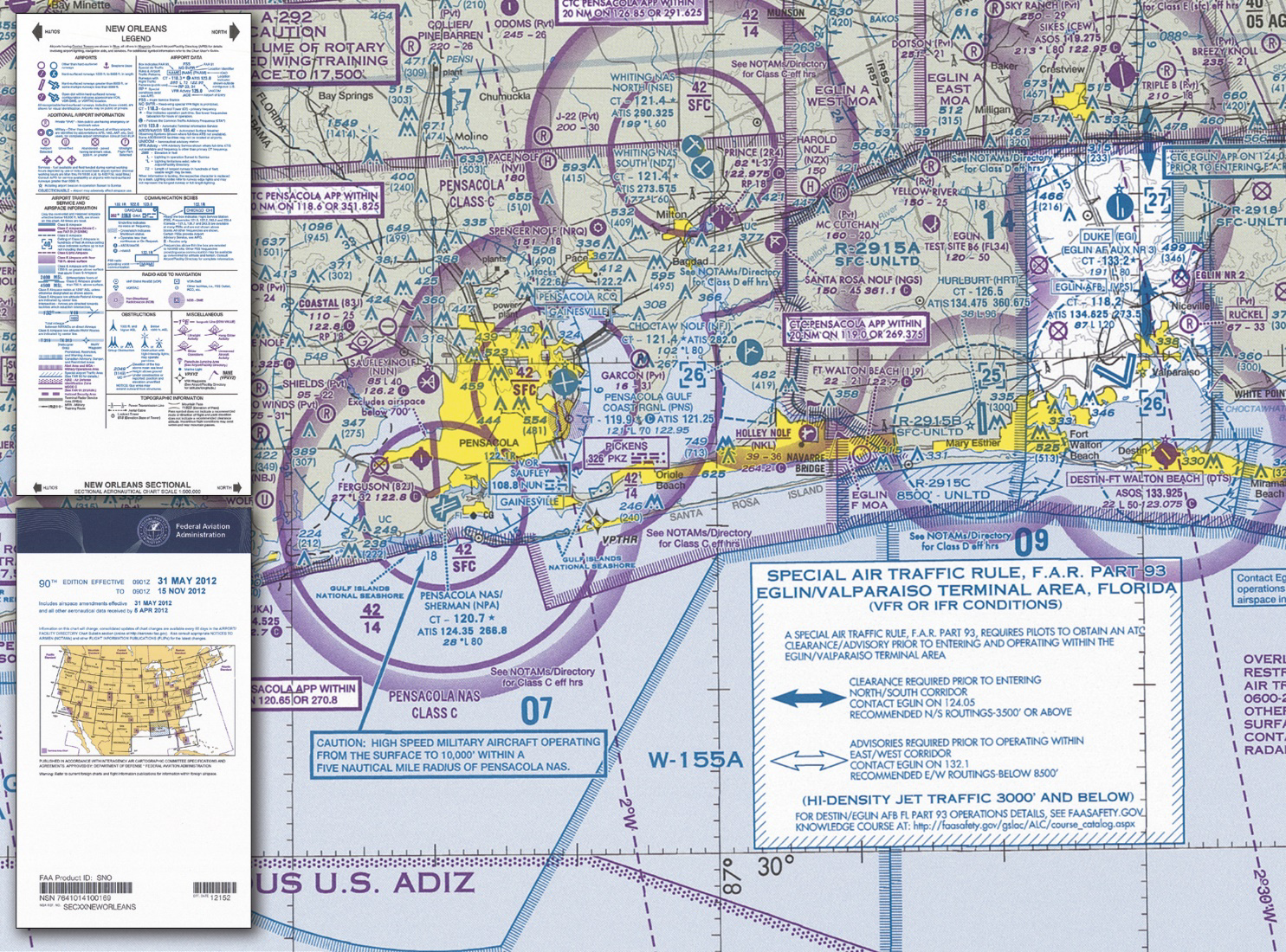
Class C — Solid Magenta Concentric Circles
Solid magenta circles around medium-traffic airports. Usually two rings. The inner ring goes from surface to 4,000 ft, and the outer ring is typically 1,200 ft to 4,000 ft.
Class D — Dashed Blue Circle
A dashed blue circle around a towered airport. Typically surface to about 2,500 ft AGL. Ceiling shown as a number in brackets like [25].
Class E Surface — Dashed Magenta Line
Dashed magenta lines indicate Class E starting at the surface. Authorization required, same as Class D.
Class E (700 ft) — Soft Magenta Gradient
Soft magenta gradient = Class E starts at 700 ft AGL. Below 700 ft is Class G. Drone operations OK without authorization.
Class E (1200 ft) — Soft Blue Gradient
Soft blue gradient = Class E starts at 1,200 ft AGL. Below 1,200 ft is Class G. Drone operations OK.
Class G — Not Depicted
Everything not marked as something else is Class G. No authorization needed.
The Gradient Trick
When the FAA asks “what altitude does Class E begin?” look for the gradient:
- Soft magenta gradient → 700 ft AGL
- Soft blue gradient → 1,200 ft AGL
- No gradient and far from airports → 1,200 ft AGL (default)
- Dashed magenta line → Surface (authorization needed at all altitudes)
Common Exam Scenarios
“Can I fly at this location?”
- Find the point on the chart
- What airspace is it in? (Look for blue/magenta boundaries, gradients)
- Check altitude markers: does controlled airspace start at the surface?
- Below the floor of controlled airspace = Class G = no authorization needed
“What is the floor of this Class B shelf?”
- Read the bottom number in the altitude marker
- “SFC” means surface, a number means hundreds of feet MSL
Quick Check
Q: You see “100/SFC” inside a solid magenta circle. Can you fly at 200 ft AGL? A: No. The airspace extends from the surface to 10,000 ft. Authorization required at any altitude.
Q: You see “70/30” on a Class B shelf. Can you fly at 200 ft AGL? A: Yes. Controlled airspace starts at 3,000 ft MSL. Below that is Class G.
Q: What does a soft magenta gradient indicate? A: Class E starting at 700 ft AGL. Below 700 ft is Class G.
What’s Next?
Next we’ll learn to read airport symbols, obstacle markers, and other critical symbols on sectional charts.
This free course covers the essential knowledge, but if you want video walkthroughs, practice exams, and instructor support, Pilot Institute’s Part 107 course is the most comprehensive option available.