Coordinates, Terrain & Magnetic Variation
Reading GPS Coordinates
The FAA will give you coordinates and ask you to find a point on the chart, or show a point and ask for coordinates.
The Grid System
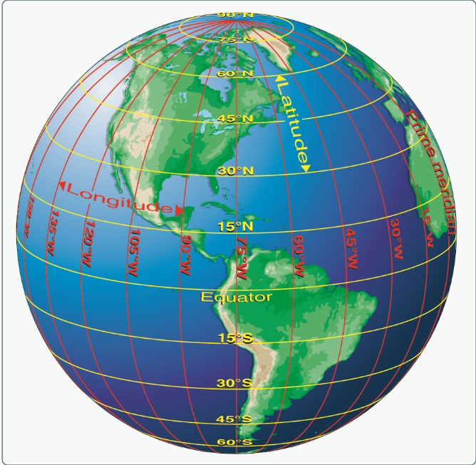
- Latitude: Lines running east-west (parallel to the equator), measured north-south from the equator (0° to 90°)
- Longitude: Lines running north-south, measured east-west from the Prime Meridian (0° to 180°)
- Grid lines on sectionals are at 30-minute intervals (half-degree)
- Tick marks at 1-minute intervals along the chart edges
Reading Coordinates
Coordinates are always latitude first, longitude second:
- N 33°27’ = 33 degrees, 27 minutes north latitude
- W 112°03’ = 112 degrees, 03 minutes west longitude
Key conversions:
- 1 degree = 60 minutes
- 1 minute of latitude = 1 nautical mile
- 1 degree of latitude = 60 nautical miles
Finding a Point on the Chart
- Start with latitude (find the horizontal band)
- Narrow down with longitude (find the vertical band)
- Use the 30-minute grid lines to locate the right quadrangle
- Use tick marks on the edges for finer precision
When the FAA gives you coordinates like “46.9°N, 96.8°W”, first find the latitude line, then the longitude. The intersection is your target area.
MSL vs AGL — The Critical Distinction
- MSL (Mean Sea Level): Altitude measured from average sea level. Used in airspace definitions, altimeter readings, and on sectional charts.
- AGL (Above Ground Level): Height above the ground directly below your drone.
Your 400-foot Part 107 limit is AGL. But airspace boundaries on charts are shown in MSL. You have to do the math.
Ground elevation is 2,000 ft MSL. You fly at 400 ft AGL, so your drone is at 2,400 ft MSL. A Class D floor at 2,500 ft MSL means you’re 100 ft below it. Legal.
Topographic Colors
The chart background color indicates terrain elevation:
| Color | Elevation Range |
|---|---|
| Green | Near sea level (0-1,000 ft) |
| Light yellow/green | 1,000-2,000 ft |
| Yellow/brown | 2,000-5,000 ft |
| Brown | 5,000-8,000 ft |
| Dark brown/maroon | 8,000+ ft |
| Blue | Water features |
Flying in a green area (low elevation)? Your 400 ft AGL is roughly the same as 400 ft MSL. In the brown mountains, ground at 5,000 ft MSL means your 400 ft AGL flight is at 5,400 ft MSL. That could put you in controlled airspace.
Spot Elevations and Contour Lines
- Spot elevations: Dots with elevation numbers (in MSL) showing specific high and low points
- Contour lines: Brown lines showing elevation. Closer lines = steeper terrain
- Peak markers: Triangle or star symbols at mountain summits with MSL elevation
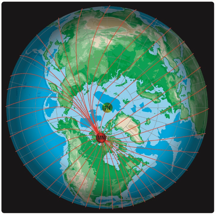
Magnetic Variation
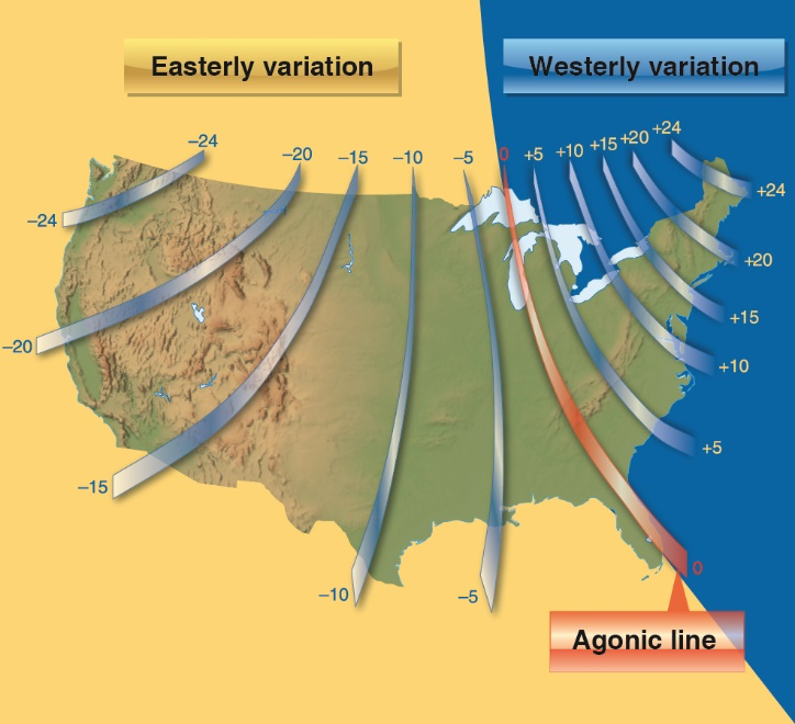
True north (geographic pole) and magnetic north (where your compass points) are not the same. The gap between them is magnetic variation.
On sectional charts, isogonic lines show variation:
- Dashed magenta lines with numbers like
14°Wor12°E - West variation: Magnetic north is west of true north
- East variation: Magnetic north is east of true north
The Conversion
Common memory aids:
- “East is least, West is best” — subtract east variation, add west variation
- Or use “Can Dead Men Vote Twice At Elections”: Compass ± Deviation = Magnetic ± Variation = True
The FAA may give you a compass heading and ask for the true heading (or vice versa). Apply the variation: West = add, East = subtract.
Quick Check
Q: How many nautical miles is 1 minute of latitude? A: 1 nautical mile.
Q: Your ground elevation is 3,000 ft MSL. You fly at 400 ft AGL. What is your MSL altitude? A: 3,400 ft MSL.
Q: What does a brown background color on a sectional chart indicate? A: Higher elevation terrain (5,000-8,000 ft).
What’s Next?
Now let’s put it all together with a step-by-step chart reading walkthrough, exactly like you’ll see on the exam.
This free course covers the essential knowledge, but if you want video walkthroughs, practice exams, and instructor support, Pilot Institute’s Part 107 course is the most comprehensive option available.