Airports & Obstacles on Charts
Airport Symbols — The Easiest Points on the Exam
Airport symbols are straightforward once you know the system. The FAA tests two things here: whether the airport has a control tower, and what type of runway surface it has.
Towered vs Non-Towered
- Blue airport symbol = has an operating control tower. Likely controlled airspace, authorization probably required.
- Magenta airport symbol = non-towered airport. May or may not be in controlled airspace.
Runway Type by Symbol Shape
- Solid/hard shape = hard-surface runway (paved)
- Open/circle shape = soft-surface (turf, gravel, water)
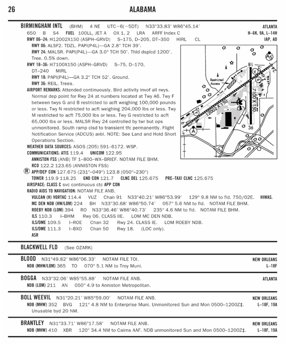
Reading Airport Data Blocks
Next to each airport symbol is a block of information. Here’s how to read it:
Towered Airport (Blue)
- Airport name and city
CT= Control Tower, followed by tower frequency (e.g., CT 125.3)- Field elevation in feet MSL
- Runway length (in hundreds of feet, e.g., “65” = 6,500 ft)
L= lighted,*= part-time lighting
Non-Towered Airport (Magenta)
- Airport name and city
CTAFfrequency (Common Traffic Advisory Frequency, pilots self-announce)- Field elevation in feet MSL
- Runway length
The FAA often asks about CTAF vs tower frequency. CTAF is for non-towered airports where pilots coordinate with each other. Tower frequency is for talking to ATC at towered airports.
Heliports and Seaplane Bases
- Heliport: Circle with an “H” inside (blue if towered, magenta if not)
- Seaplane base: Anchor symbol with an “S” (same color convention)
Obstacle Symbols
Individual Obstacles (Towers, Buildings)
- Triangle with a dot at the top
- Two numbers typically shown:
- Top number (bold) = height MSL
- Bottom number (parentheses) = height AGL
- Lightning bolt next to it = lighted at night
The FAA will show an obstacle that’s 1,200 ft MSL (400 ft AGL) and ask if you can fly at 400 ft AGL nearby. Yes. You can fly up to 400 ft above the top of the obstacle if you’re within 400 ft of it laterally (in uncontrolled airspace). So up to 800 ft AGL near that tower.
Group of Obstacles
- Multiple triangle symbols clustered together
- May show a single height for the group or individual heights
- Relevant for inspection work
Under Construction
- UC next to the symbol means “under construction”
- The height shown is the planned final height
- Treat it as if it’s already that tall
Maximum Elevation Figure (MEF)
Look for large numbers in the middle of each quadrangle (grid square). This represents the highest point in that area including terrain and obstacles, with a safety margin added:
- MEF = highest obstacle + 100 ft (for obstacles 200+ ft AGL) or + 200 ft (natural terrain)
- Useful for situational awareness
- The FAA rarely tests MEF directly. They test individual obstacle heights instead.
Chart Legend
The sectional chart legend (printed on every chart) explains every symbol. On the exam, the Testing Supplement includes the complete legend.
Spend time studying the chart legend before the exam. Many questions reference obscure symbols you’ll only recognize if you’ve reviewed the legend.
Quick Check
Q: A blue airport symbol indicates what? A: A towered airport with an operating control tower.
Q: An obstacle shows 1200 (400 AGL) with a lightning bolt. What does the lightning bolt mean? A: The obstacle is lighted at night.
Q: What is MEF? A: Maximum Elevation Figure. The highest point in a quadrangle area including terrain and obstacles, with a safety margin added.
What’s Next?
Now let’s learn to read coordinates and terrain features: the remaining chart-reading skills you need for the exam.
This free course covers the essential knowledge, but if you want video walkthroughs, practice exams, and instructor support, Pilot Institute’s Part 107 course is the most comprehensive option available.