What Is Drone Mapping?
Why It Matters
Take 200 photos of a construction site from a drone flying in a grid pattern. To you, they’re just photos. To photogrammetry software, they’re millions of data points that can be stitched into a single measurable map, a 3D model, or a topographic survey accurate to within a few centimeters.
Drone mapping didn’t invent photogrammetry. Surveyors and cartographers have used aerial photography for mapping since the 1920s. What drones changed is the cost and speed. A 1,000-acre property that once required three weeks of traditional surveying can now be mapped in two days of flying plus three days of processing. The resolution is higher, the data is richer, and the entire process costs a fraction of traditional methods.
How Photogrammetry Works
The Basic Principle
Photogrammetry is the science of making measurements from photographs. The software identifies the same features across multiple overlapping images and uses triangulation to calculate the 3D position of each point.
The key requirement: every point on the ground must appear in at least three photos taken from different angles. This overlap is what allows the software to calculate depth and position.
From Photos to Data
The photogrammetry pipeline follows these steps:
- Image alignment: the software matches features across overlapping photos and calculates camera positions
- Dense point cloud: millions of 3D points are generated, creating a detailed representation of the terrain
- Mesh generation: the point cloud is connected into a 3D surface (triangulated mesh)
- Texture mapping: the original photos are draped over the mesh, creating a realistic 3D model
- Orthomosaic: photos are stitched into a single geometrically corrected map image
- Elevation data: digital surface models and digital terrain models are derived from the point cloud
What Makes It Different from a Panorama
A panorama stitches photos based on visual matching. A photogrammetric orthomosaic is geometrically corrected. Every pixel has a known real-world coordinate. You can measure distances, areas, and elevations directly from the map. It’s not a picture of a site; it’s a measurable representation of one.
What Drone Mapping Can Produce
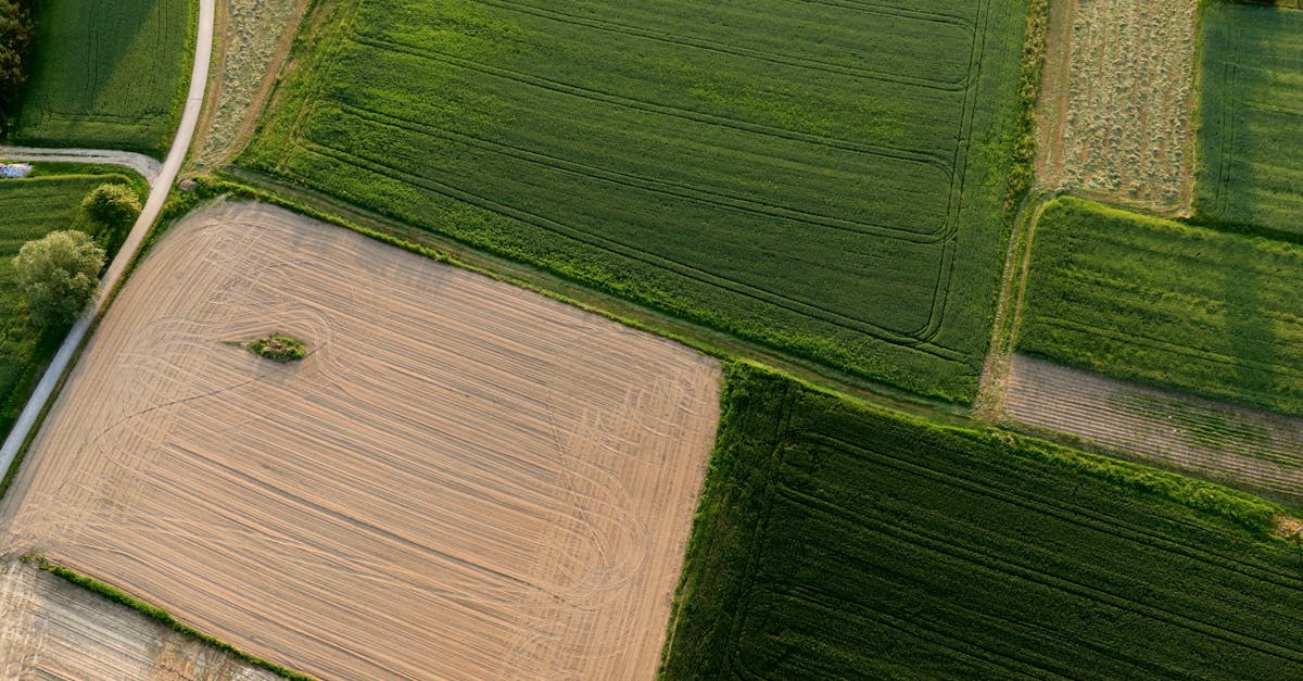
Orthomosaic Map
An orthomosaic is a single high-resolution aerial photo of the entire surveyed area, corrected for perspective distortion and camera tilt. Unlike a satellite image or a single drone photo, you can measure real distances and areas on an orthomosaic because the geometry is accurate.
Resolution depends on flight altitude. Lower altitude means higher resolution. A typical mapping flight at 60 meters (200 feet) produces an orthomosaic with 2-3 cm per pixel resolution, far sharper than commercial satellite imagery.
Digital Elevation Model (DEM)
A DEM represents the bare-earth terrain surface, with buildings and vegetation removed. It’s used for contour line generation, flood modeling, and grading plans. Two related products:
- Digital Surface Model (DSM): includes everything on the surface (buildings, trees, vehicles)
- Digital Terrain Model (DTM): bare earth only, with objects filtered out
Contour Lines
Contour lines connect points of equal elevation, showing the shape and slope of terrain. Drone-generated contours can achieve 10cm intervals or less, far more detailed than traditional survey methods for the same cost. Engineers use them for drainage planning, road design, and site grading.
3D Models
A textured 3D model of the site can be rotated, measured, and inspected from any angle. Construction managers use them for visual progress tracking, and architects use them for site context in design.
Volume Calculations
By comparing elevation data across multiple surveys, you can calculate cut and fill volumes for earthwork. Stockpile measurements, excavation tracking, and landfill monitoring are common applications.
Drone Mapping vs Traditional Surveying
| Factor | Traditional Survey | Drone Mapping |
|---|---|---|
| Speed | Weeks for large sites | Days |

| Resolution | Point measurements | Continuous surface data | | Cost | High (labor-intensive) | Lower (automated flight + processing) | | Accessibility | Limited by terrain | Can map any visible area | | Outputs | Points and lines | Orthomosaic, 3D model, DEM, contours | | Accuracy | Sub-centimeter | 2-5 cm with GCPs, sub-cm with RTK |
Drone mapping doesn’t replace traditional surveying. It complements it. Surveyors use drones for fast data collection over large areas and traditional methods for high-precision control points and legal boundary work.
Quick Check
Q: How many photos must a ground point appear in for photogrammetry to work? A: At least three photos taken from different angles.
Q: What is an orthomosaic? A: A single geometrically corrected aerial map image where every pixel has a known real-world coordinate, allowing accurate distance and area measurements.
Q: What is the key advantage of drone mapping over traditional surveying for large sites? A: Speed. A 1,000-acre property can be mapped in days rather than weeks, with continuous surface data instead of individual point measurements.
What’s Next?
Now that you understand what drone mapping produces, let’s look at the equipment you need: from mapping-capable drones to ground control points and processing software.