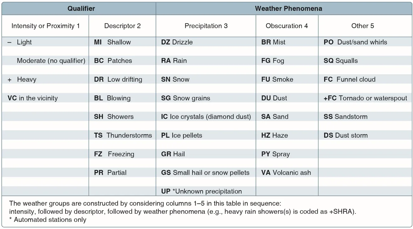
Blog
Page 5 of 9
Drone Panorama Photography: How to Shoot and Stitch
A great panorama captures a scene the way your eyes experience it. And with a drone, you can shoot from anywhere in 3D space.
Drone Photography Pricing Guide: How Much to Charge
Stop guessing at your rates. Here are real pricing benchmarks, the three pricing models, and how to calculate your minimum rate.
How Much to Charge for Drone Real Estate Videos
Figure out pricing once and for all. Here are the tiers, add-ons, and psychology behind charging what your drone real estate services are actually worth.
Drone Risk Management: Pre-Flight Safety Assessment
Every flight carries risk. A structured pre-flight assessment keeps you safe, legal, and prepared for the unexpected.
Drone Roof Inspection: Complete Guide for Pilots and Homeowners
Why drones are replacing ladders for roof inspections, how to do them right, and how to charge for them.
How Much to Charge for Drone Surveying: Pricing Guide 2026
Price too low and you work for pennies. Price too high and you lose bids. Here's the complete pricing guide with real rates for every drone surveying service.
Drone Surveying vs Mapping: What's the Difference
Surveying is measurement-focused. Mapping is visual representation-focused. They overlap but serve different purposes — here's exactly where the line is drawn.
Drone Video Editing for Beginners: Start to Finish Workflow
Raw drone footage to polished video. Here's the complete beginner workflow covering software, organization, editing, color, and export.
Drone Volume Calculations: How to Measure Stockpiles
Drones measure stockpiles faster, safer, and more accurately than ground surveys. Here's how volumetric calculations work.
Editing Drone Photos in Lightroom: Complete Workflow
From import to export, here's the exact Lightroom workflow professional drone photographers use to turn flat RAW files into stunning aerial images.