The Class E Airspace Trick That Stumps Everyone on the Part 107 Exam
Class E has three starting altitudes but only two are drawn on the chart. The invisible default rule is the #1 reason pilots lose points on airspace questions.
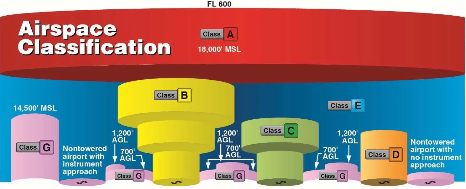
Class E airspace has three starting altitudes, but only two appear on sectional charts. Dashed magenta lines mean Class E starts at the surface. Faded magenta shading means it starts at 700 feet AGL. When nothing is depicted, Class E begins at 1,200 feet AGL by default. This invisible 1,200-foot rule is the most commonly missed concept on the Part 107 exam.
Here’s the thing about Class E airspace: it looks like nothing. On a sectional chart, you’ll see highways, airports, towers, obstacles — but Class E often hides in plain sight. And that’s exactly why it destroys exam scores.
Most drone pilots fail Part 107 questions about Class E because they’re looking for something obvious. A big circle. A bold line. Something that screams “controlled airspace.”
Class E doesn’t scream. It whispers. And if you don’t know what to listen for, you’ll pick the wrong answer every time.
Why Class E Is the Exam’s Favorite Trap
The FAA loves Class E questions because they test whether you actually understand the rules — or whether you’re just guessing based on chart colors.
Here’s what makes it tricky: Class E has three different starting altitudes, and only two of them are actually drawn on the chart. The third one? It’s invisible. It’s just the default rule that applies everywhere else.
Most study guides mention this in passing. Then they move on. But on the actual exam, you’ll get questions like: “What class of airspace is at position X?” And position X will be in the middle of nowhere, with no markings around it.
If you picked Class G, you fell for the trap. The answer is probably Class E — starting at 1,200 feet AGL.
Let me break down exactly how to read Class E on a sectional chart so this never happens to you.
Reading Class E on Sectional Charts
Class E shows up in three forms on sectional charts. Two are visual. One is invisible. Memorize these three and you’ll nail every Class E question on the exam.
Dashed Magenta Lines
This is the most obvious one, and it’s where most people start learning.
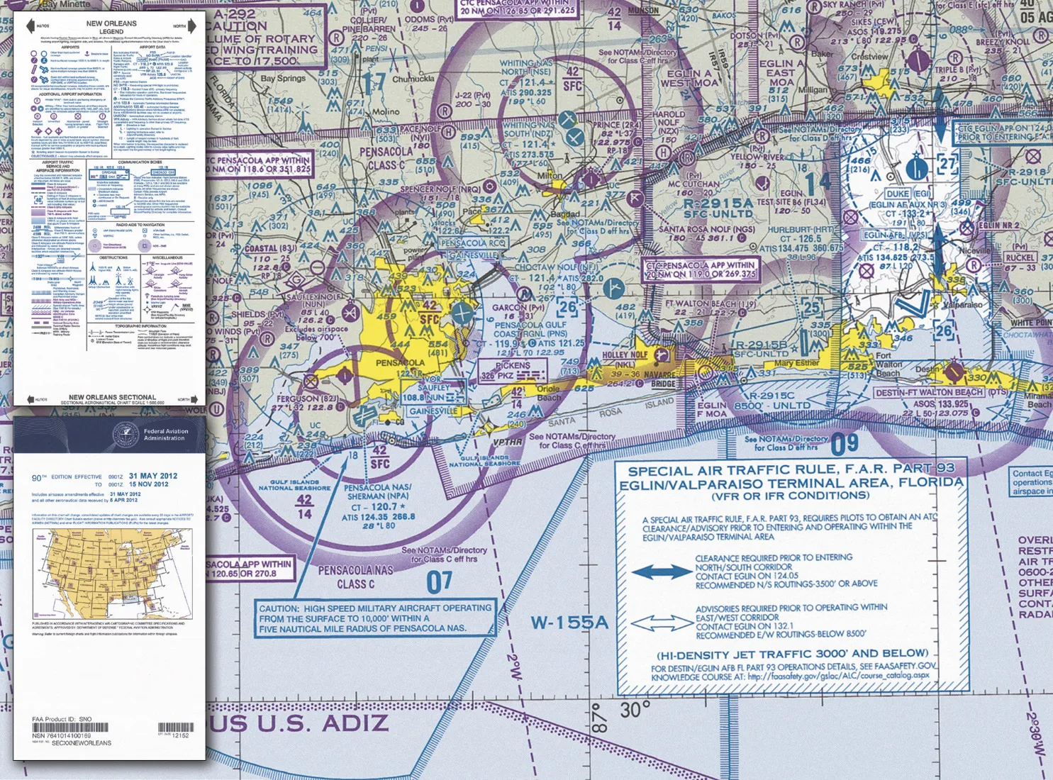
A dashed magenta line means Class E starts at the surface. Not at 700 feet. Not at 1,200 feet. At the surface. Right where you’re standing.
If you see a dashed magenta line on the chart, that’s Class E surface area. It looks like someone took a purple pen and drew a jagged circle around something. Usually, that something is a Class D airport.
Here’s the key point: when you’re inside a dashed magenta line, you’re in controlled airspace from the ground up. At 50 feet. At 100 feet. At 400 feet. All of it is Class E.
For drone pilots, this matters a lot. I’ll explain why in a minute.
Faded Magenta Areas
This is where people start getting confused.
Look at a sectional chart and you’ll see large areas filled with a faded, soft magenta color. Not a line — an area. It looks like someone lightly shaded a region with a purple highlighter.
This faded magenta area means Class E starts at 700 feet AGL.
Not at the surface. At 700 feet above ground level.
So what’s below 700 feet? Class G. Uncontrolled airspace.
For typical drone operations — flying at 200 or 400 feet AGL — you’re usually below the Class E floor. You’re in Class G. No authorization needed.
But here’s where the exam tries to trick you: they’ll show you a location inside the faded magenta area and ask what airspace you’re in at 200 feet. If you say Class E, you’re wrong. You’re in Class G because you haven’t reached the 700-foot floor yet.
Multiple flight instructors teach the same memory trick for this one: the faded magenta looks like a “faded fence.” A fence starts at the ground. But a faded fence? It starts higher up. At 700 feet.
It’s silly, but it works. Faded fence equals 700 feet.
The Hidden Default: 1,200 Feet
This is the one that stumps almost everyone.
What if you’re looking at a location on the sectional chart and there’s no dashed magenta line and no faded magenta area? What airspace are you in?
Most people assume Class G. Uncontrolled. After all, nothing is marked, right?
Wrong.
Class E is the default airspace above 1,200 feet AGL across most of the United States. If nothing else is depicted, Class E starts at 1,200 feet.
Let me say that again because it’s the single most missed rule on the Part 107 exam:
If nothing is depicted, Class E starts at 1,200 feet AGL.
So when the exam shows you a random point out in rural Kansas with zero airspace markings and asks “What class of airspace is at 1,500 feet AGL?” — the answer is Class E.
At 200 feet AGL at that same spot? Class G. You’re below the 1,200-foot floor.
At 1,500 feet AGL? Class E. You’re above the floor.
This default rule is so easy to forget because it’s invisible. There’s nothing to see on the chart. You just have to know it.
Class E Extensions Explained
There’s one more Class E feature that shows up on exams: extensions.
You know those dashed blue circles around Class D airports? Sometimes you’ll see faded magenta lines extending outward from those circles, like fingers reaching into the surrounding airspace.
These are Class E extensions. They exist to protect instrument approaches into the Class D airport.
Here’s how they work: pilots flying instrument approaches need controlled airspace for separation. The Class D circle only extends a few miles from the airport. But instrument approaches often start farther out. So the FAA creates Class E extensions to provide that controlled airspace along the approach path.
On the chart, these extensions look like faded magenta rectangles or lines pointing away from the Class D circle.
The key detail: these extensions are Class E surface areas. They start at the surface, just like the dashed magenta lines.
If you’re flying a drone inside a Class E extension, you’re in controlled airspace from the ground up. Same rules apply as if you were inside the dashed magenta line.
Why This Matters for Your Drone Flight
Here’s where all this chart-reading knowledge becomes practical.
Part 107 has different rules depending on whether you’re in controlled or uncontrolled airspace. The biggest difference? LAANC authorization.
If you’re flying in controlled airspace at or below 400 feet AGL, you need LAANC authorization before you fly. Period.
If you’re in uncontrolled airspace (Class G), you don’t need LAANC. Just fly safely and follow Part 107 rules.
So the question becomes: when are you actually in controlled Class E airspace as a drone pilot?
Class E surface area (dashed magenta line): You’re in controlled airspace from the ground up. At any altitude you’d fly a drone, you’re in Class E. LAANC authorization required.
Class E at 700 feet (faded magenta area): You’re in Class G below 700 feet. For typical drone flights at 200-400 feet, you’re in uncontrolled airspace. No LAANC needed.
Class E at 1,200 feet (default, nothing depicted): You’re in Class G below 1,200 feet. No LAANC needed for normal drone operations.
Class E extensions: Same as surface areas. Controlled from the ground up. LAANC required.
See the pattern? The only time Class E matters for your drone flight is when it starts at the surface. The 700-foot and 1,200-foot versions? You’re flying below them. They exist up there in the sky, but down where you’re flying, it’s Class G.
This is why understanding the chart symbols matters so much. If you misidentify a faded magenta area as a surface area, you’ll think you need LAANC when you don’t. If you miss a dashed magenta line, you’ll fly without authorization in controlled airspace.
Both are problems. One wastes your time. The other violates federal regulations.
Class E at a Glance
| Chart Symbol | Class E Starts At | Drone at 400 ft AGL? |
|---|---|---|
| Dashed magenta line | Surface (SFC) | Class E — LAANC required |
| Faded magenta area | 700 feet AGL | Class G — No LAANC |
| Nothing depicted | 1,200 feet AGL | Class G — No LAANC |
| Faded magenta extension | Surface (SFC) | Class E — LAANC required |
Memorize this table. Screenshot it. Write it on a flashcard. If you can recall these four rows from memory, you’ll get every Class E question right.
How to Practice This
Reading about Class E is one thing. Recognizing it on an actual sectional chart is another.
The best way to prepare is to open a sectional chart — SkyVector has free ones online — and start testing yourself.
Pick a random point on the chart. Ask yourself: what class of airspace is here at 200 feet? At 400 feet? At 800 feet?
Check for dashed magenta lines first. Then check for faded magenta areas. If you see neither, apply the 1,200-foot default rule.
Do this fifty times and it becomes automatic. The symbols start jumping out at you.
When you’re staring at a 2D sectional, it’s easy to forget that airspace is three-dimensional. The faded magenta area isn’t just a shape on paper — it’s an invisible ceiling at 700 feet with Class E stacked on top. Below that ceiling is Class G.
Mentally picture that layer cake and the chart symbols start making sense.
Don’t Let One Topic Cost You the Exam
Class E airspace is one of those topics that seems simple in a study guide but becomes surprisingly difficult on the actual exam. The FAA knows exactly where the confusion points are, and they write questions to exploit them.
The good news? It’s completely learnable. You don’t need aviation experience or special spatial reasoning skills. You just need to memorize the three rules: dashed magenta is surface, faded magenta is 700 feet, nothing means 1,200 feet.
Once you lock that in, Class E questions go from impossible to automatic.
Frequently Asked Questions
What does a dashed magenta line mean on a sectional chart? Class E airspace starting at the surface. Inside this boundary at any altitude, you’re in controlled airspace and need LAANC authorization before flying.
What does faded magenta shading mean? Class E starting at 700 feet AGL. Below 700 feet is Class G (uncontrolled), so typical drone flights at 200-400 feet AGL don’t require LAANC in these areas.
What airspace is it if nothing is marked on the chart? Class E begins at 1,200 feet AGL by default. Below 1,200 feet is Class G. Drone operations at typical altitudes don’t need LAANC.
What are Class E extensions? Faded magenta rectangles or lines extending outward from Class D airport circles. These are surface-level Class E areas protecting instrument approach paths. LAANC is required for drone flights within them.
Do I need LAANC in faded magenta areas? No, not at typical drone altitudes. Class E at 700 feet means controlled airspace starts there. At 200-400 feet AGL you’re in Class G, below the Class E floor.
How do I memorize Class E for the exam? Three rules: dashed magenta = surface, faded magenta = 700 feet AGL, nothing depicted = 1,200 feet AGL. Practice by picking random points on SkyVector sectional charts until it’s automatic.
If you want a structured way to prepare for every topic on the Part 107 exam — not just Class E — check out our free Part 107 Complete Course. It covers everything the FAA will throw at you, with practice questions that mimic the actual exam format.
And if you’re someone who learns best from books, pick up the ASA Remote Pilot Test Prep. It’s updated for the 2025-2026 testing cycle and includes the exact figure references you’ll see on exam day.
Either way, don’t walk into the testing center with fuzzy knowledge of Class E. It’s too easy of a topic to lose points on.