The 400-Foot Rule Explained: What Counts as a Structure?
Everyone knows the 400-foot limit. But the structure exception lets you fly much higher — if you know what actually counts as a structure.
Under FAA Part 107.51(b), the 400-foot rule limits drones to 400 feet AGL, but there’s an exception: within 400 feet horizontally of a man-made structure (buildings, cell towers, bridges, cranes), you may fly up to 400 feet above that structure. Mountains, hills, and trees do not count as structures. This exception does not override LAANC altitude limits in controlled airspace.
Every drone pilot knows the 400-foot rule. It’s drilled into your head from day one. But if you’re studying for your FAA Part 107 exam, knowing “stay under 400 feet” isn’t going to be enough to pass. The FAA loves to test the exception to this rule, and they absolutely love to test your definition of a “structure.” If you misunderstand either of these concepts, you’ll miss questions on the test — and worse, you could accidentally violate federal regulations on a real job.
The Basic Rule: 400 Feet AGL
Under Part 107.51(b), the baseline rule is simple: you cannot fly your drone higher than 400 feet above ground level (AGL).
Pay close attention to those three letters: AGL. The regulation does not say MSL, or mean sea level. MSL is what you see printed as elevations on sectional charts. It represents the actual altitude of the earth relative to the ocean. AGL is the distance between your drone and the ground directly beneath it at any given moment.
If you’re flying over a beach at sea level, 400 feet AGL and 400 feet MSL are exactly the same thing. But if you’re flying over a town that sits at 1,000 feet MSL, you can legally fly your drone up to 1,400 feet MSL, because you’re still only 400 feet above the ground.
Your drone’s altimeter needs to be set to show AGL so you always know exactly where you stand with the FAA.
The Big Exception: Flying Near Structures
Now for the exception that creates so much confusion on test day. The exact same regulation (Part 107.51(b)) states that if your drone is flying within 400 feet of a structure, you can fly your drone up to 400 feet above that structure.
This exception exists for a highly practical reason: infrastructure inspection. The FAA understands that commercial drone pilots are routinely hired to inspect cell towers, skyscrapers, wind turbines, and bridges. It would be impossible to do your job if you were capped at 400 feet above the ground when the building you’re inspecting is 800 feet tall.
If you stay within a 400-foot horizontal radius of that 800-foot building, your maximum altitude legally becomes 1,200 feet AGL.

What Exactly Counts as a Structure?
Because this exception gives you a massive amount of extra altitude, the FAA is very specific about what qualifies. For the purposes of the Part 107 knowledge test, a structure is anything man-made that has a fixed location on the ground.
Think about the things you would naturally expect: office buildings, residential homes, water towers, radio antennas, cell towers, communication towers, bridges, and construction cranes. If humans built it, bolted it down, poured a foundation for it, and it’s not designed to move, it’s a structure.
What the FAA Does NOT Consider a Structure
This is where the test writers will try to trip you up. There are two massive exam traps you need to watch out for.
First: Mountains and natural terrain features do not count as structures.
Second: Trees do not count as structures.
The FAA will deliberately give you a scenario where you’re flying near a 600-foot hill or a 100-foot tall tree, and ask how high you can fly. If you blindly add 400 feet to the hill or the tree, you’ll get the question wrong. You’re strictly bound to the standard 400-foot AGL limit when flying near natural features.
Nature is not a structure, no matter how tall it is.
AGL and Hills: Where Do You Start Measuring?
Building on that natural terrain trap, let’s talk about how AGL works on uneven ground. The 400-foot limit is always measured from the ground directly below your drone.
If you launch from the top of a 500-foot hill, your 400 feet is measured from the dirt on top of that hill. You don’t measure your altitude from the valley floor below you.
If you fly out over the valley, your maximum altitude drops accordingly because the ground is rising up to meet you. Always keep your drone within 400 feet of the earth beneath it, regardless of where you took off or how high you started.
Quick Reference: The 400-Foot Rule
- Standard Limit: 400 feet AGL (Above Ground Level)
- The Exception: Fly up to 400 feet above a structure, provided you stay within 400 feet of it horizontally
- What is a structure? Anything man-made with a fixed location (towers, buildings, bridges, cranes)
- Not a structure: Mountains, hills, terrain, trees
- Airspace Rule: The structure exception does NOT override LAANC altitude limits in controlled airspace
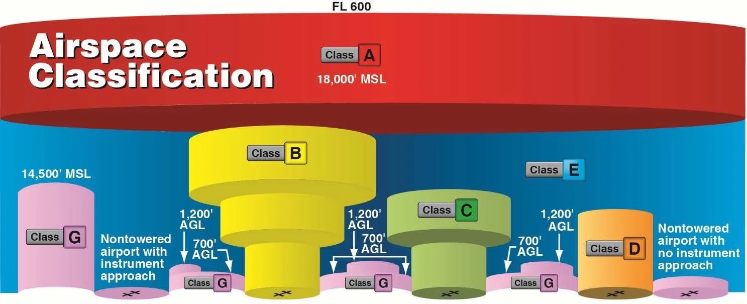
Controlled Airspace Changes Everything
There is one major caveat to the structure exception that trips up a lot of pilots. The ability to fly 400 feet above a structure does not magically override airspace rules. If that structure is located in controlled airspace, you must still get LAANC authorization before you fly.
Your LAANC authorization also dictates your maximum altitude. LAANC uses a grid system, and it grants altitudes based on that grid, not based on the structures sitting inside it. If you get LAANC approval to fly at 400 feet AGL in Class C airspace, but you want to inspect a 300-foot tower, you cannot automatically fly up to 700 feet. You’re bound by the altitude granted in your LAANC authorization.
You would need to request a higher altitude through the FAA’s DroneZone portal to legally use the structure exception. Always check your airspace authorization limits before relying on the structure rule.
Beating the Classic Exam Trap
Let’s put all of this together and look at the most common scenario you’ll face on the FAA knowledge test.
The FAA will show you a sectional chart snippet. On that chart, there’s a symbol indicating a tall tower with a number next to it, like “1200.” They’ll ask you: “What is the maximum legal altitude you can fly your drone near this tower?”
Here’s how you solve it:
- The number “1200” on a sectional chart tells you the top of that structure is at 1,200 feet MSL
- Find the ground elevation beneath the tower. Let’s say the chart shows the ground elevation is 200 feet MSL
- The tower itself is exactly 1,000 feet tall (1,200 MSL minus 200 MSL)
- Because it’s a man-made structure, add 400 feet to the 1,000-foot height of the tower
- Your maximum legal altitude is 1,400 feet AGL (1,000 + 400)
- Translated back to MSL for the chart: 1,600 feet MSL (1,400 AGL + 200 ground elevation)
If you just guessed 400 feet or 1,200 feet, you missed it. You have to do the math: find the structure height in AGL, then add 400 feet.
Real-World Application
Understanding this rule isn’t just about passing a multiple-choice test. It keeps you out of trouble with the FAA and keeps manned aircraft safe. When you’re out in the field doing an inspection, use your drone’s altimeter to track your AGL height. Set a hard ceiling on your controller if your software allows it.
If you’re inspecting a 1,000-foot tower, keep your drone within that 400-foot lateral bubble. The moment you finish the inspection and fly away from the tower to transit back to your launch point, you need to descend below 400 feet AGL immediately. The exception only applies when you’re actively near the structure. Flying at 1,400 feet in the middle of open airspace because you were “just near a tower five minutes ago” is a blatant violation.
Frequently Asked Questions
Does the 400-foot structure exception apply to mountains or hills? No. Mountains, hills, and all natural terrain are not structures under Part 107. You’re strictly bound to 400 feet AGL measured from the ground directly beneath your drone.
How close do I need to be to a structure to use the exception? Within a 400-foot horizontal radius. The moment you fly outside that bubble, you must descend to the standard 400-foot AGL limit immediately.
Does the structure exception override LAANC altitude limits? No. LAANC grants altitudes based on a grid system, not nearby structures. If authorized for 400 feet AGL in controlled airspace, you cannot fly 400 feet above a nearby tower without requesting higher altitude through the FAA DroneZone portal.
What’s the difference between AGL and MSL? AGL (Above Ground Level) is the distance between your drone and the ground directly beneath it. MSL (Mean Sea Level) is altitude relative to the ocean. The 400-foot rule uses AGL. Sectional charts show MSL elevations.
Do trees count as structures? No. The FAA explicitly excludes trees. Even a 100-foot tree doesn’t qualify. You must stay within 400 feet AGL of the ground beneath it.
How do I calculate max altitude near a tower on a sectional chart? Subtract ground elevation (MSL) from the tower’s top height (MSL) to find its physical height, then add 400 feet. Example: tower at 1,200 MSL on 200-foot ground = 1,000-foot tower. Max legal altitude: 1,400 feet AGL.
Ready to master the Part 107 exam and fly with confidence? We cover every regulation, chart reading trick, and airspace rule in depth so you pass on your first attempt. Check out the Pilot Institute Part 107 Course for a comprehensive, video-based study guide, or dive straight into our free Part 107 Complete Course to get your license and start flying commercially.